
Barton Hills, Michigan facts for kids
Quick facts for kids
Barton Hills, Michigan
|
||
|---|---|---|
|
Village
|
||
| Barton Hills Village | ||

Walter Esch Village Hall on Barton Shore Drive
|
||
|
||

Location within Washtenaw County
|
||

Barton Hills, Michigan
Location in Michigan

Barton Hills, Michigan
Location in the United States
|
||
| Country | United States | |
| State | Michigan | |
| County | Washtenaw | |
| Township | Ann Arbor | |
| Established | 1913 | |
| Incorporated | 1973 | |
| Government | ||
| • Type | Board of Trustees | |
| Area | ||
| • Total | 0.76 sq mi (1.97 km2) | |
| • Land | 0.76 sq mi (1.97 km2) | |
| • Water | 0.00 sq mi (0.00 km2) | |
| Elevation | 942 ft (287 m) | |
| Population
(2020)
|
||
| • Total | 316 | |
| • Density | 415.79/sq mi (160.54/km2) | |
| Time zone | UTC-5 (Eastern (EST)) | |
| • Summer (DST) | UTC-4 (EDT) | |
| ZIP code(s) |
48105 (Ann Arbor)
|
|
| Area code(s) | 734 | |
| FIPS code | 26-05660 | |
| GNIS feature ID | 2398044 | |

Barton Hills is a small village located in Washtenaw County, in the state of Michigan. In 2020, about 316 people lived there. The village is found within Ann Arbor Charter Township, just northwest of the city of Ann Arbor.
The village was first created by Alex Dow, who was the president of Detroit Edison, a power company. He bought the land for the Barton Dam. Barton Hills was planned to be a special, wooded neighborhood right outside Ann Arbor. In 1944, the land was sold to the people living there. Later, in 1973, it officially became a village. The streets in Barton Hills used to be owned by a private company, but the village bought them in 2010.
Contents
History of Barton Hills
How Barton Hills Began
In the early 1900s, the land where Barton Hills is now was used for cows by a local dairy farm. Around 1910, the Detroit Edison Company needed more electricity. They decided to build dams and power stations along the Huron River. So, they bought a lot of land, including the dairy farm. The Barton Dam was built in 1913.
In 1913, Detroit Edison started an area called "Huron Farms" on the north side of the Huron River, next to Ann Arbor. The company also used its land for farming, like growing crops and raising dairy cows. A famous architecture company, Olmsted Brothers, helped design the streets and property lines. They also planned for the area to be replanted with trees, as it was quite bare at first.
Early Homes and Rules
By the early 1920s, some Detroit Edison leaders had built homes along the river. In 1924, the company officially divided the land into building lots and called it Barton Hills. They added special rules to the property deeds. These rules made sure Barton Hills would stay a controlled residential area. For example, homes built in the 1920s had to be designed by a professional architect.
The Country Club and Growth
The Barton Hills Country Club, the only business in the village, started in 1917. Being a member of this club was seen as a sign of importance. In 2020, almost half of the people living in Barton Hills were members.
At first, Barton Hills grew slowly because it was considered too far from Ann Arbor. The Great Depression in the 1930s also slowed down building. It wasn't until after World War II, in the 1950s and 1960s, that many new homes were built. Today, there are very few empty lots left.
Becoming an Official Village
By the 1940s, after the Great Depression and World War II, the community was costing Detroit Edison too much money. The company decided to give the land to the residents. In return, the residents agreed to take care of the water system, roads, and other services. However, the community didn't become an official village until much later. On December 12, 1973, Barton Hills became the first "home rule" village in Washtenaw County. This means it could make its own local laws.
Geography of Barton Hills
Barton Hills is a small village, covering about 0.76 square miles (1.97 square kilometers) of land. It sits on the north side of Barton Pond, which is part of the Huron River. Barton Pond is a reservoir, which is like a large artificial lake, created by the Barton Dam. The dam is located in the nearby city of Ann Arbor.
Population Information
| Historical population | |||
|---|---|---|---|
| Census | Pop. | %± | |
| 1980 | 357 | — | |
| 1990 | 320 | −10.4% | |
| 2000 | 335 | 4.7% | |
| 2010 | 294 | −12.2% | |
| 2020 | 316 | 7.5% | |
| U.S. Decennial Census | |||
2010 Census Details
In 2010, there were 294 people living in Barton Hills. These people lived in 123 households, and 93 of these were families. Most of the people living in the village were White (about 88%). There were also people of Asian (about 7%), African American (1%), and other backgrounds. About 6% of the population identified as Hispanic or Latino.
Most households (about 70%) were married couples living together. About 25% of households had children under 18. The average age of people in the village was about 54 years old. About 22% of residents were under 18, and nearly 30% were 65 or older. The population was almost evenly split between males (48%) and females (52%).
Education
Barton Hills is part of the Ann Arbor Public Schools system. However, there are no schools located directly within the village itself. Students from Barton Hills attend schools in the wider Ann Arbor area.
Images for kids
-
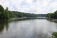
Barton Pond, created from the Barton Dam -
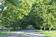
Barton Shore Drive, a street in the village -
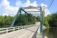
The Maple–Foster Bridge


See also
 In Spanish: Barton Hills (Míchigan) para niños
