Ann Arbor Charter Township, Michigan facts for kids
Quick facts for kids
Ann Arbor Township, Michigan
|
||
|---|---|---|
|
Charter township
|
||
| Charter Township of Ann Arbor | ||
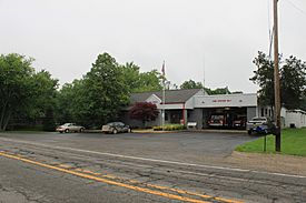
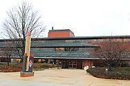
Township Hall and Fire Station on Pontiac Trail
|
||
|
||
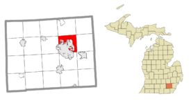
Location within Washtenaw County (red) and the administered village of Barton Hills (pink)
|
||
| Country | United States | |
| State | Michigan | |
| County | Washtenaw | |
| Organized | 1827 | |
| Area | ||
| • Total | 16.88 sq mi (43.72 km2) | |
| • Land | 16.73 sq mi (43.33 km2) | |
| • Water | 0.15 sq mi (0.39 km2) | |
| Elevation | 945 ft (288 m) | |
| Population
(2020)
|
||
| • Total | 4,673 | |
| • Density | 276.84/sq mi (106.885/km2) | |
| Time zone | UTC-5 (Eastern (EST)) | |
| • Summer (DST) | UTC-4 (EDT) | |
| ZIP code(s) |
48104, 48105, 48109
(Ann Arbor) |
|
| Area code(s) | 734 | |
| FIPS code | 26-03020 | |
| GNIS feature ID | 1625838 | |
Ann Arbor Charter Township is a special type of local government area called a charter township in Washtenaw County, Michigan. In 2020, about 4,673 people lived here. The township is right next to the city of Ann Arbor. Even though they are neighbors, the township and the city manage themselves separately.
Contents
Exploring Ann Arbor Township's Communities
Ann Arbor Township is home to a few distinct communities. Each has its own story and history.
Barton Hills Village
- Barton Hills is a small village located inside the township. It's a quiet residential area.
Foster: A Historic Settlement
- Foster is an unincorporated community within the township. It started around 1877 as the site of Cornwell Mills. It was also known as Cornwell or Newport. The community later became known as Foster, named after an early settler, Samuel Foster.
Geddes: Along the Huron River
- Geddes is another unincorporated community. It's found just south of the Huron River. The first settlers arrived here in 1824. A post office named Geddes opened in 1875, named after its first postmaster, John Geddes. The community was also a stop on the Michigan Central Railroad in 1878.
A Look at Ann Arbor Township's History
The "Township of Ann Arbour" was officially created in 1827. This happened thanks to the Legislative Council of the Michigan Territory. The Village of Ann Arbour was formed in 1833. This village later grew into the City of Ann Arbor. Villages usually stay part of their township. However, the Village of Ann Arbour became fully separate from the township when it reorganized as the City of Ann Arbor.
Geography and Natural Features
Ann Arbor Township covers about 16.88 square miles (43.72 square kilometers). Most of this area is land, with a small part being water.
Rivers and Waterways
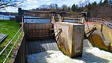
The Huron River flows right through the township. You can find the Geddes Dam in the southeastern part of the township. The Border-to-Border Trail also runs along the river near Geddes Dam. While Barton Dam is in the city of Ann Arbor, the township's boundaries touch Barton Pond, which is the reservoir created by the dam.
Major Roads for Travel
Several important highways pass through Ann Arbor Township. These roads help people travel easily to and from the area.
 US 23 runs through the township. It also forms part of the border with the city of Ann Arbor.
 Bus. US 23 is a business route. It briefly goes through the township before joining US 23.
 M-14 also runs through the township. It shares parts of its route with US 23 and Bus. US 23.
Who Lives in Ann Arbor Township?
In 2000, there were 4,720 people living in the township. The average age was 41 years old. The township is a diverse place where people from many backgrounds live and work.
Economy: Businesses and Jobs
Ann Arbor Township is home to some well-known companies. These businesses provide many jobs for the community.
- Domino's Pizza has its main headquarters located right here in the township.
- In 2007, Toyota employed 932 people at its Toyota Technical Center. Calty Design Research Inc., a Toyota design company, also has a facility in the township.
- Con-way, a transportation and logistics company, moved its main office to Ann Arbor Township in 2011.
Education Opportunities
Students in Ann Arbor Charter Township attend schools in the Ann Arbor Public Schools district. For higher education, the main campus of Washtenaw Community College is located in the southeastern part of the township.
Images for kids
-
Domino's Pizza headquarters
See also
 In Spanish: Municipio de Ann Arbor para niños
 | Janet Taylor Pickett |
 | Synthia Saint James |
 | Howardena Pindell |
 | Faith Ringgold |


