Barwon Heads Airport facts for kids
Quick facts for kids
Barwon Heads Airport
|
|||||||||||||||
|---|---|---|---|---|---|---|---|---|---|---|---|---|---|---|---|

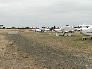
Planes parked at Barwon Heads airport
|
|||||||||||||||
| Summary | |||||||||||||||
| Airport type | Public | ||||||||||||||
| Serves | Geelong | ||||||||||||||
| Location | Connewarre, Australia | ||||||||||||||
| Elevation AMSL | 50 ft / 15 m | ||||||||||||||
| Coordinates | 38°15′30″S 144°26′00″E / 38.25833°S 144.43333°E | ||||||||||||||
| Runway | |||||||||||||||
|
|||||||||||||||
|
Reference
|
|||||||||||||||
Barwon Heads Airport (ICAO: YBRS) is a small airfield located on the Bellarine Peninsula in Victoria, Australia. It is close to the town of Barwon Heads. This airport is mainly used for smaller planes. People use it for fun scenic flights, private trips, and learning how to fly.
Contents
Barwon Heads Airport: A Hub for Small Planes
Barwon Heads Airport is a public airport. It is designed for light aircraft. This means it handles smaller planes, not large passenger jets. The airport is an important spot for local aviation.
What You'll Find at the Airport
Even though it's a small airport, Barwon Heads has useful facilities. In 2008, five new buildings called hangars were built. These hangars are where planes are stored and maintained. There is also a new car park for visitors.
The airport has a flight training school. This school helps people learn to become pilots. It has two classrooms for lessons. You can also find fuel for planes here. Inside the main building, there are showers and toilets. There's also a kitchen, snack machines, and a comfy lounge area. You can even find a seafood shop at the airport!
Understanding the Runways
Barwon Heads Airport has two runways for planes to take off and land. The main runway is made of gravel. It runs from north to south. This runway is 762 meters (2500 feet) long.
There is also a smaller runway. This one is made of grass. It runs from east to west. It is 430 meters (1410 feet) long. This grass runway is mostly used by very light planes called ultralights. It's also used by other light aircraft when the wind is very strong.
A Look Back: Airport History
Over the years, there have been discussions about how the airport space is used. For example, the owners of Barwon Heads Airport have talked about skydiving activities nearby. They wanted to make sure that skydiving was done safely. This was to avoid any issues with planes using the runways.
In 2005, some rules were put in place about skydiving near the airport. The airport owners always focus on keeping the area safe for everyone. This includes pilots, passengers, and people on the ground.

