Bayou Grande Cheniere Mounds facts for kids

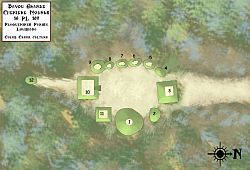
Layout of mounds at the Bayou Grande Cheniere Mounds
|
|
| Location | Plaquemines Parish, Louisiana, |
|---|---|
| Region | Plaquemines Parish, Louisiana |
| Coordinates | 29°29′46.68″N 89°47′33.324″W / 29.4963000°N 89.79259000°W |
| History | |
| Founded | 700 CE |
| Abandoned | 1200 CE |
| Cultures | Coastal Coles Creek culture |
| Site notes | |
| Excavation dates | 1926, 2003 |
| Responsible body: private | |
The Bayou Grande Cheniere Mounds (also known as 16 PL 159) is an exciting archaeological site in Plaquemines Parish, Louisiana. This area is located near the southeastern tip of Louisiana.
This ancient site was built by a group of people called the Coastal Coles Creek culture. They lived here from about 875 CE to 1200 CE. This time period covers the Early Coles Creek period and goes into the Coles Creek/Plaquemine period.
Contents
What Are the Bayou Grande Cheniere Mounds?
This special site is found on a natural raised area next to Bayou Grande Chenière. Think of a natural levee as a slightly higher strip of land formed by a river or bayou.
How Many Mounds Are There?
The site has twelve large mounds! Eleven of these mounds are placed around a central open area called a plaza. Imagine a big, flat space where people might have gathered.
One extra mound is about 75 meters (246 feet) south of the main group. It was connected to the other mounds by a path built by people, called a causeway. This causeway also linked the site to Bayou Grande Chenière.
What Did the Plaza Look Like?
The central plaza is shaped like an oval. It measures about 100 feet (30 meters) from north to south and 75 feet (23 meters) from east to west.
Different Kinds of Mounds
- Mound 1: This is the biggest mound. It's shaped like a cone and is about 60 feet (18 meters) tall. It sits on the eastern side of the plaza.
- Mound 10: This mound is on the southern edge of the plaza.
- Mound 3: This mound is on the northern edge. Both Mound 10 and Mound 3 are platform mounds. These mounds usually have a flat top, which might have been used for buildings or ceremonies.
- Mounds 4 to 9: These are a series of smaller mounds connected together. They form the western edge of the plaza.
Why Is This Site Special?
The Bayou Grande Cheniere Mounds site is very unusual because of its large size and the many mounds it has. Most settlements from the Coastal Coles Creek culture only had about three mounds around a plaza. This site's large layout is most similar to another big Coles Creek settlement called the Greenhouse Site in Avoyelles Parish, Louisiana.
Exploring the Mounds: Excavations
Archaeologists have studied the Bayou Grande Cheniere Mounds to learn more about the people who lived there.
Early Discoveries
In 1926, Henry B. Collins, Jr., who worked for the Smithsonian Institution, was the first to dig at the site. Later, in 2000, the mound site was carefully mapped out.
Recent Digs
In January 2003, a team from Louisiana State University led by Joe W. Saunders and Timothy Schilling did more field excavations. They found pottery that helped them figure out when people lived there. The pottery showed the site was used from 875 CE to 1200 CE. This time includes different periods like the Bayou Ramos, Bayou Cutler, and St. Gabriel phases.
Archaeologists did not find anything from before the Troyville culture or after the Plaquemine period. This helps them understand the timeline of the site.
New Technology Helps
In the late 2000s, NASA's Stennis Space Center worked with the United States Army Corps of Engineers and Tulane University. They used modern technology to survey the marshes of southeastern Louisiana, including the Bayou Grande Cheniere site. This survey helped them discover the man-made causeway that connected the site to the bayou!
 | Emma Amos |
 | Edward Mitchell Bannister |
 | Larry D. Alexander |
 | Ernie Barnes |


