
Bear Mountain Bridge Road facts for kids
Quick facts for kids |
|
|
Bear Mountain Bridge Road
|
|

Road on Anthony's Nose, 2009
|
|
| Location | Cortlandt, NY |
|---|---|
| Area | 3 miles (4.8 km); 18 acres (7.3 ha) |
| Built | 1923 |
| Architectural style | Tudorbethan |
| MPS | Hudson Highlands MRA |
| NRHP reference No. | 82001274 |
| Added to NRHP | November 23, 1982 |
Bear Mountain Bridge Road is a special road in Cortlandt, New York. It is about 3 miles (4.8 km) long and has two lanes. This road is part of US 6 and US 202. It connects to the Bear Mountain Bridge on one side. Some local people call it the Goat Trail.
Contents
Exploring Bear Mountain Bridge Road
This road winds around the side of Anthony's Nose. This is a steep, rocky mountain on the east side of the Hudson River. Anthony's Nose is the most southern peak of the Hudson Highlands.
What Can You See?
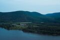
As you drive or walk the first mile from NY 9D, the road climbs about 200 feet (61 m). You will reach a scenic overlook with amazing views. From here, you can see Iona Island and Dunderberg Mountain. You can also spot the city of Peekskill.
There are signs that tell you about the area's history. This spot was important during the American Revolutionary War. The Hudson River Chain was placed here to block British ships. The Battle of Forts Clinton and Montgomery also happened nearby.
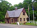
The Old Toll House
Near the eastern end of the road, about 2.5 miles (4.0 km) from the bridge, you'll find an old toll house. It looks like a Tudor Revival-style building. This building used to collect tolls from drivers. It was also where the toll collector lived.
In 2002, the Town of Cortlandt fixed up the old toll house. Now, it's an information center and gift shop for visitors. There's also a small parking lot nearby. This lot is used by hikers who want to explore Anthony's Nose. They can follow a popular trail through Camp Smith to the famous Appalachian Trail.
Where the Road Ends
At its eastern end, the road goes down to the level of the Hudson River. It then runs next to the river. Before it meets US 9 at Annsville Circle, you can see the Indian Point power plant. This view is across a bay and the Metro-North railroad tracks.
A Bit of History
The Harriman family helped build the Bear Mountain Bridge in the mid-1920s. The state asked them to build this road at the same time. It was important to connect the new bridge to US 9 near Peekskill.
The road was designed to be higher on the mountain than another road called the Storm King Highway. That road was built earlier, further up the river. Like the Storm King Highway, Bear Mountain Bridge Road has a stone wall. This wall was made from a huge amount of rock, about 21,000 cubic yards (16,000 m3), that was dug out during the road's construction.
The Road Becomes Public
The law that allowed the bridge to be built said that the road and bridge would become state property after 30 years. This would happen without any cost to the state. When this time came, the toll collected on the eastern side of the road was stopped. The toll collector and his wife moved to the western toll house. He then became the bridge manager until he retired.
In 1982, the road and the old toll house were added to the National Register of Historic Places. This means they are important historical sites. They were part of a larger group of historical places in the Hudson Highlands. This was the only property in Westchester County included in that group.
Images for kids
-
Original toll house, no longer in use
-
View of the Hudson River from near Bear Mountain Bridge Road scenic overlook
-

Bear Mountain Bridge Road at twilight


