Beardsley, Arizona facts for kids
Quick facts for kids
Beardsley, Arizona
|
|
|---|---|
|
Populated place
|
|

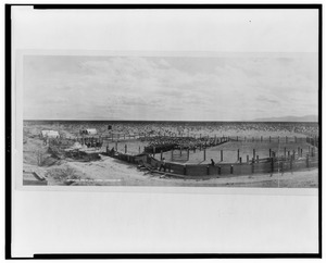
Photo of Beardsley’s Sheep pens in 1908.
|
|
| Country | United States |
| State | Arizona |
| County | Maricopa |
| Elevation | 1,263 ft (385 m) |
| Time zone | UTC-7 (Mountain (MST)) |
| • Summer (DST) | UTC-7 (MST) |
| Area code(s) | 602 |
| FIPS code | 04-05420 |
| GNIS feature ID | 1154 |
Beardsley is a small community located in Maricopa County, Arizona, United States. It is found within the area known as Sun City West. The land here is about 1,263 feet (385 meters) above sea level.
The place was named after William H. Beardsley. He was an important person who started an irrigation project in this area in 1888. Irrigation helps bring water to dry land for farming.
History of Beardsley
Beardsley began around the year 1880. It grew up around a railroad station, which was a busy spot for trains. For many years, Beardsley was a key place where sheep were sheared. This means their wool was cut off. It was a stop on the Santa Fe, Prescott & Phoenix Railroad line.
In the 1940s, parts of the town were cleared away. This was done to make more room for the railroad. By 1960, the population of Beardsley was very small, with only 12 people living there.


