Beaverdale, Pennsylvania facts for kids
Quick facts for kids
Beaverdale, Pennsylvania
|
|
|---|---|

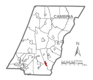
Location within Cambria County
|
|
| Country | United States |
| State | Pennsylvania |
| County | Cambria |
| Townships | Summerhill, Adams |
| Area | |
| • Total | 1.53 sq mi (3.97 km2) |
| • Land | 1.53 sq mi (3.97 km2) |
| • Water | 0.00 sq mi (0.00 km2) |
| Elevation | 1,913 ft (583 m) |
| Population
(2020)
|
|
| • Total | 959 |
| • Density | 625.98/sq mi (241.62/km2) |
| Time zone | UTC-5 (Eastern (EST)) |
| • Summer (DST) | UTC-4 (EDT) |
| ZIP code |
15921
|
| FIPS code | 42-04768 |
| GNIS feature ID | 2389187 |
Beaverdale is a small community in Cambria County, Pennsylvania, in the United States. It's known as a "census-designated place" (CDP), which means it's a special area the government tracks for population numbers. In 2010, about 1,035 people lived here. Before that, this area was called Beaverdale-Lloydell.
Where is Beaverdale Located?
Beaverdale is in the southeastern part of Cambria County. You can find it using its coordinates: 40.322095 degrees North and 78.697636 degrees West. Most of Beaverdale is in Summerhill Township. A small part of it also reaches into Adams Township. The community of Lloydell is in the southeastern section of this area.
Pennsylvania Route 869 goes through Beaverdale. This road leads about 3 miles (4.8 km) west to a place called Sidman. It also goes about 18 miles (29 km) southeast to Interstate 99 near St. Clairsville. If you like nature, Blue Knob State Park is about 10 miles (16 km) to the southeast. The city of Johnstown is about 16 miles (26 km) to the west.
The U.S. Census Bureau says that Beaverdale covers a total area of about 1.5 square miles (4.0 square kilometers). All of this area is land. The community is located in a valley near the South Fork of the Little Conemaugh River.
People Living in Beaverdale
| Historical population | |||
|---|---|---|---|
| Census | Pop. | %± | |
| 2020 | 959 | — | |
| U.S. Decennial Census | |||
According to the census from the year 2000, there were 1,230 people living in Beaverdale. There were 485 households, which are like homes where people live. Out of these, 337 were families. The population density was about 913 people per square mile (353 people per square kilometer).
Most of the people in Beaverdale were White (99.35%). A very small number were African American (0.16%), Native American (0.08%), or from two or more races (0.41%). About 0.08% of the population was Hispanic or Latino.
In 2000, about 32% of households had children under 18 living with them. More than half, 53.4%, were married couples living together. About 11.1% of households had a female head of the house with no husband present.
The people in Beaverdale were of different ages. About 25.9% were under 18 years old. About 8% were between 18 and 24. The largest group, 27.1%, was between 25 and 44 years old. About 16.9% of the people were 65 years old or older. The average age in Beaverdale was 37 years.
See also
 In Spanish: Beaverdale-Lloydell para niños
 | Ernest Everett Just |
 | Mary Jackson |
 | Emmett Chappelle |
 | Marie Maynard Daly |


