Becerril facts for kids
Becerril is a town and municipality in the Department of Cesar in Colombia. It's a place with a rich history and interesting geography.
Quick facts for kids
Becerril
|
||
|---|---|---|
|
Town
|
||
|
||

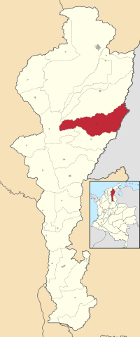
Location of the municipality and town of Becerril in the Department of Cesar.
|
||
| Country | Colombia | |
| Region | Caribbean | |
| Department | Cesar | |
| Foundation | 1594 | |
| Area | ||
| • Total | 1,144 km2 (442 sq mi) | |
| Elevation | 200 m (700 ft) | |
| Population
(Census 2018)
|
||
| • Total | 20,477 | |
| • Density | 17.899/km2 (46.359/sq mi) | |
| Time zone | UTC-5 | |
| Website | becerril-cesar.gov.co/ |
|
Where is Becerril?
The municipality of Becerril is located in Colombia. It shares a border to the east with the country of Venezuela. Here, you can find the Serranía del Perijá mountain range.
To the north, Becerril borders the municipality of Codazzi. To the west, it's next to El Paso. To the south, it borders La Jagua de Ibirico.
Becerril covers an area of about 1,143 square kilometers. Most of its land is flat plains. The only exception is the mountainous area on its western border with Venezuela. The region gets its water from the Maracas River and the Tocuy River, along with other smaller streams.
What's the Weather Like?
Becerril has a warm climate all year round. The average temperature is about 30°C (86°F).
The year is divided into two main seasons. There are two dry "summer" seasons. There are also two "winter" seasons, which are rainy.
| Climate data for Becerril (Socomba), elevation 170 m (560 ft), (1981–2010) | |||||||||||||
|---|---|---|---|---|---|---|---|---|---|---|---|---|---|
| Month | Jan | Feb | Mar | Apr | May | Jun | Jul | Aug | Sep | Oct | Nov | Dec | Year |
| Mean daily maximum °C (°F) | 34.5 (94.1) |
34.9 (94.8) |
34.5 (94.1) |
34.0 (93.2) |
33.1 (91.6) |
33.2 (91.8) |
33.7 (92.7) |
33.3 (91.9) |
32.9 (91.2) |
32.2 (90.0) |
32.4 (90.3) |
33.5 (92.3) |
33.5 (92.3) |
| Daily mean °C (°F) | 28.1 (82.6) |
28.9 (84.0) |
28.9 (84.0) |
28.3 (82.9) |
27.7 (81.9) |
27.8 (82.0) |
28.1 (82.6) |
27.9 (82.2) |
27.2 (81.0) |
26.7 (80.1) |
26.9 (80.4) |
27.4 (81.3) |
27.8 (82.0) |
| Mean daily minimum °C (°F) | 20.7 (69.3) |
21.2 (70.2) |
21.9 (71.4) |
22.5 (72.5) |
22.4 (72.3) |
22.3 (72.1) |
22.0 (71.6) |
22.1 (71.8) |
22.0 (71.6) |
22.0 (71.6) |
21.8 (71.2) |
21.2 (70.2) |
21.8 (71.2) |
| Average precipitation mm (inches) | 17.2 (0.68) |
46.3 (1.82) |
77.4 (3.05) |
160.4 (6.31) |
209.8 (8.26) |
135.4 (5.33) |
113.9 (4.48) |
160.3 (6.31) |
192.4 (7.57) |
220.6 (8.69) |
157.3 (6.19) |
50.8 (2.00) |
1,477.7 (58.18) |
| Average precipitation days | 1 | 3 | 6 | 11 | 14 | 11 | 12 | 14 | 15 | 16 | 12 | 5 | 119 |
| Average relative humidity (%) | 65 | 67 | 70 | 76 | 81 | 80 | 76 | 79 | 81 | 82 | 81 | 74 | 76 |
| Mean monthly sunshine hours | 279.0 | 240.0 | 223.2 | 192.0 | 195.3 | 204.0 | 220.1 | 210.8 | 180.0 | 182.9 | 204.0 | 254.2 | 2,585.5 |
| Mean daily sunshine hours | 9.0 | 8.5 | 7.2 | 6.4 | 6.3 | 6.8 | 7.1 | 6.8 | 6.0 | 5.9 | 6.8 | 8.2 | 7.1 |
| Source: Instituto de Hidrologia Meteorologia y Estudios Ambientales | |||||||||||||
How Did Becerril Start?
The town of Becerril was founded a long time ago, on March 4, 1594. It was started by a Spanish Captain named Bartolomé de Aníbal Paleólogo Becerra. This happened during the time when Spain was exploring and settling in the Americas.
The official document of the town's founding was written by a scribe named Martin Camacho. It was signed by important people like Governor Francisco Manco de Contreras, Captain Bartolomé de Aníbal Paleólogo Becerra, and Captain Cristobal de Almonacid.
The first mayor of Becerril was Gregorio Romallo. The first church built in the town was named Santa Eugenia.
Captain Becerra also brought about 500 cattle to the region. These animals helped provide food for the town and for the village of Cartagena de Indias. The Magdalena River was used as a route to transport supplies.
Much later, in 1977, Becerril officially became a municipality within the Department of Cesar.
See also
 In Spanish: Becerril (Cesar) para niños
 | May Edward Chinn |
 | Rebecca Cole |
 | Alexa Canady |
 | Dorothy Lavinia Brown |


