
Bello, Antioquia facts for kids
Quick facts for kids
Bello
Bello
|
|||
|---|---|---|---|
|
Municipality and City
|
|||
| Municipality of Bello | |||

Center of the city
|
|||
|
|||
| Nickname(s):
・Marco Fidel Suárez's Cradle
・Cacique Niquia's Empire |
|||
| Motto(s):
City of progress
|
|||

Location of the municipality and town of Bello, Antioquia in the Antioquia Department of Colombia
|
|||

Bello
Location in Colombia
|
|||
| Country | |||
| Founded | 1676 | ||
| Area | |||
| • Municipality and City | 147.8 km2 (57.1 sq mi) | ||
| • Urban | 22.07 km2 (8.52 sq mi) | ||
| Elevation | 1,310 m (4,300 ft) | ||
| Population
(2023 census)
|
|||
| • Municipality and City | 595.457 | ||
| • Density | 4.0288/km2 (10.435/sq mi) | ||
| • Urban | 562.880 | ||
| • Urban density | 25.504/km2 (66.056/sq mi) | ||
| • Metro | 3,312,165 | ||
| Demonym(s) | Bellanita | ||
| Time zone | UTC-5 (Colombia Standard Time) | ||
| Area code(s) | 57 + | ||
| Website | Official website: http://www.bello.gov.co | ||

.svg)
Bello (say it: BAY-yo) is a lively city and a municipality (like a county or district) in Antioquia Department, Colombia. It's a close neighbor to Medellín, which is the capital city of the department. Bello is an important part of the Metropolitan Area of the Aburrá Valley.
This city is bordered by other municipalities. To the north is San Pedro de los Milagros, to the east is Copacabana, and to the south and west is Medellín. To the far west is San Jerónimo.
Bello is a key area for growth in the northern part of the Aburrá Valley (also called Valle de Aburrá). Because it's part of the Metropolitan Area of Aburrá Valley (AMVA), some public services are managed for the whole region. Bello has a few cool nicknames, like "Cacique Niquia's Empire," "Marco Fidel Suárez's Cradle," and "Artist's City."
Contents
- History of Bello: From Hato Viejo to City of Artists
- Geography and Climate of Bello
- Who Lives in Bello? (Demographics)
- How Bello is Governed (Politico-Administrative Structures)
- Bello's Economy: How People Make a Living
- Communication in Bello
- Education in Bello
- Sports in Bello
- See also
- Images for kids
History of Bello: From Hato Viejo to City of Artists
The name "Bello" means "Beautiful" in English. The city was first started in 1676 and was called "Hato Viejo." Later, the department changed its name to Bello. This was done to honor Andrés Bello, a very smart person from Latin America who lived from 1781 to 1865. Bello officially became a municipality in 1913.
Bello is also known as the "City of Artists" in Colombia. Its current mayor is Carlos Alirio Muñoz López.
In July 1541, a group of explorers led by Jerónimo Luis Tejelo found the wide valley of Los Aburrá. This valley was home to local farmers who lived in scattered houses, forming small groups. This was especially true in the area now known as Bello, where the Niquías people lived.
In 1574, a Spanish person named Gaspar de Rodas asked for land in the Aburrá Valley. He wanted to raise livestock and grow crops there to feed the people who were exploring the area. He was given land from a hill called "Asientos viejos de Aburrá" all the way down to the Niquía territory. In 1576, Rodas took control of the land, using it for animal pens and farms. From 1613, the area became known as Hatoviejo.

Early settlers built chapels on their farms to show their importance. This means Hatoviejo didn't start as a typical village with a main square and streets. Instead, it grew around these chapels. Some of these chapels included Our Lady of Chiquinquirá (built in 1653) and Our Lady of the Rosary (built in 1720).
The Hatoviejo Parish Church of Our Lady of the Rosary was later taken down in 1788. A new chapel, the Chapel of Hatoviejo, was built in its place in 1792, and it is still standing today. By the end of the 1700s, in 1788, Hatoviejo became a "party," which meant it was a district under the control of the town of Nuestra Señora de la Candelaria in Medellin.

In Hatoviejo, the land was organized based on what people did for a living. People often referred to areas as "Calle arriba" (Up the road) and "Calle Abajo" (Down the road). The main square and the Church of the Rosary were the central points. On December 28, 1883, the name of the village was changed from Hatoviejo to Bello. This change was requested by people who felt the name "Hato" (which means a place for animals) made them feel looked down upon. They believed "Bello" was a more cultured and fitting name, honoring Andrés Bello.
Geography and Climate of Bello
.JPG)
Bello is located in the Aburrá Valley, which is a valley found within the Andes mountain range. It sits right next to Medellín, at the northern edge of the valley. The weather here is generally warm, and gentle winds blow throughout the year.
The city covers a total area of about 142.36 square kilometers. About 19.7 square kilometers are urban areas (city land), and 122.66 square kilometers are rural areas (countryside). The valley floor is very built up, while the mountain slopes around it are also quite busy. The Medellín River flows through the valley from south to north, and 57 smaller streams join it along its 70-kilometer path.
The urban part of Bello is like a gently sloping plain, going down from 1600 meters to 1400 meters above sea level. Bello is in the northern part of the valley, and the mountains around the city are taller than 2,500 meters. The most important mountain feature is the Cerro Quitasol, a pyramid-shaped mountain that is 2,880 meters tall. It's seen as Bello's guardian mountain.
What is Bello's Climate Like?
Because Bello is located in the tropics, it doesn't have big seasonal changes like summer or winter. The average rainfall is about 1347 millimeters per year. The temperature is influenced by different climate zones, but the main area has an average temperature of 25.7°C (about 78°F) all year round. It has both dry and wet periods, and winds help keep it cool.
Trade winds blow into the area from the lower valleys of the Cauca river to the west and the Magdalena river to the east. These winds create a layer of warm air. This means that the lower parts of Bello and some nearby areas can be more humid and have higher temperatures. As a result, northern municipalities like Bello, Copacabana, Girardota, and Barbosa are often warmer than Medellín, even though they are close by.
| Climate data for Bello (Tulio Ospina), elevation 1,438 m (4,718 ft), (1981–2010) | |||||||||||||
|---|---|---|---|---|---|---|---|---|---|---|---|---|---|
| Month | Jan | Feb | Mar | Apr | May | Jun | Jul | Aug | Sep | Oct | Nov | Dec | Year |
| Record high °C (°F) | 32.6 (90.7) |
34.0 (93.2) |
33.8 (92.8) |
33.2 (91.8) |
32.8 (91.0) |
38.0 (100.4) |
32.6 (90.7) |
34.2 (93.6) |
32.8 (91.0) |
31.6 (88.9) |
31.2 (88.2) |
33.2 (91.8) |
38.0 (100.4) |
| Mean daily maximum °C (°F) | 27.8 (82.0) |
28.5 (83.3) |
28.6 (83.5) |
27.8 (82.0) |
27.9 (82.2) |
28.2 (82.8) |
28.4 (83.1) |
28.7 (83.7) |
28.2 (82.8) |
27.3 (81.1) |
27.1 (80.8) |
27.0 (80.6) |
27.9 (82.2) |
| Daily mean °C (°F) | 21.7 (71.1) |
22.2 (72.0) |
22.3 (72.1) |
22.1 (71.8) |
22.1 (71.8) |
22.3 (72.1) |
22.5 (72.5) |
22.5 (72.5) |
21.9 (71.4) |
21.2 (70.2) |
21.3 (70.3) |
21.4 (70.5) |
22 (72) |
| Mean daily minimum °C (°F) | 16.5 (61.7) |
16.1 (61.0) |
17.1 (62.8) |
17.5 (63.5) |
17.5 (63.5) |
17.1 (62.8) |
16.6 (61.9) |
16.9 (62.4) |
16.9 (62.4) |
17.0 (62.6) |
17.0 (62.6) |
16.8 (62.2) |
16.9 (62.4) |
| Record low °C (°F) | 8.6 (47.5) |
8.9 (48.0) |
11.0 (51.8) |
11.0 (51.8) |
11.0 (51.8) |
10.2 (50.4) |
10.0 (50.0) |
9.4 (48.9) |
10.6 (51.1) |
11.5 (52.7) |
10.0 (50.0) |
8.6 (47.5) |
8.6 (47.5) |
| Average precipitation mm (inches) | 38.1 (1.50) |
53.0 (2.09) |
99.6 (3.92) |
161.0 (6.34) |
197.4 (7.77) |
139.5 (5.49) |
120.9 (4.76) |
127.1 (5.00) |
174.4 (6.87) |
215.6 (8.49) |
136.5 (5.37) |
79.4 (3.13) |
1,542.4 (60.72) |
| Average precipitation days (≥ 1.0 mm) | 8 | 9 | 15 | 20 | 21 | 17 | 17 | 17 | 20 | 23 | 18 | 11 | 193 |
| Average relative humidity (%) | 77 | 74 | 75 | 78 | 78 | 76 | 74 | 73 | 77 | 80 | 80 | 79 | 77 |
| Mean monthly sunshine hours | 186.0 | 149.6 | 161.2 | 132.0 | 148.8 | 174.0 | 207.7 | 192.2 | 159.0 | 133.3 | 138.0 | 164.3 | 1,946.1 |
| Mean daily sunshine hours | 6.0 | 5.3 | 5.2 | 4.4 | 4.8 | 5.8 | 6.7 | 6.2 | 5.3 | 4.3 | 4.6 | 5.3 | 5.3 |
| Source: Instituto de Hidrologia Meteorologia y Estudios Ambientales | |||||||||||||
Who Lives in Bello? (Demographics)
| Years Census |
Population total |
% Increase Base year 1964 |
|---|---|---|
| 1964* | 95.463 | 100% |
| 1973* | 109.173 | 114% |
| 1985* | 214.921 | 225% |
| 1993* | 293.841 | 307% |
| 2005* | 371.973 | 389% |
| * Census carried out by the DANE | ||

Based on the 2005 DANE census, Bello has 371,973 people living there. It is the second-largest city in the Metropolitan Area of the Aburrá Valley. The entire metropolitan area has a total of 3,312,165 people.
Bello has about 2496 people per square kilometer. About 47.1% of the population are male, and 52.9% are female. Most people over 5 years old, about 92.9%, can read and write. Public services are widely available. For example, 96.9% of homes have electricity, 96.4% have water, and 91.4% have telephone service.
According to a 2004 survey, most households in Bello are in socioeconomic level 2 (low), which is 39.3%. Next is level 3 (medium-low) at 36.1%, and then level 1 (low-high) at 20.2%. A smaller number of homes are in levels 4 (middle) and 5 (medium-high), mostly in the rural areas.
Ethnicity in Bello
The 2005 DANE census also looked at the ethnic makeup of Bello:
- Mestizos (people of mixed European and Indigenous ancestry) & Whites: 92.2%
- Afro-Colombians (people of African descent): 7.7%
- Indigenous (native peoples): 0.1%
How Bello is Governed (Politico-Administrative Structures)

Bello is run by a democratic system. This means that people vote for their leaders. The city's government is set up based on Colombia's Political Constitution of 1991. Bello has a Mayor, who is in charge of the executive power, and a Municipal Council, which handles the legislative power (making laws).

The Mayor of Bello is the main leader of the city government. The Mayor represents the city in legal matters and manages its administration. This position is chosen by popular vote, and the Mayor serves for four years. The current mayor is Carlos Alirio Muñoz Lopez.
The Mayor's main jobs include managing the city's money and working for the well-being of the citizens. They also create local plans to improve life, such as programs for health, housing, education, and roads. The Mayor also helps keep public order.
The Municipal Council of Bello is a group of 19 councillors chosen by the people. They also serve for four years. The Council is the law-making body for the city. They approve plans from the Mayor, set the rules for the budget, and approve the yearly income and spending plans.
To help the Mayor manage the city, there are 14 different departments, called secretariats. These include:
- Administrative Services
- Government
- Sport and Recreation
- Education and Culture
- Internal Control
- Health
- Planning
- Infrastructure
- Environment
- General Secretariat
- Finance
- Welfare and Social Integration
- Transport and Traffic
- Entrepreneurship
How Bello is Divided


 The city part of Bello is divided into 12 communes. These communes are then split into 82 neighborhoods. In the rural areas, there is one township and 15 small villages called hamlets.
In the 2011 local elections, many people voted blank ballots. This meant that blank votes, un-marked votes, and invalid votes made up 56.7% of the total, which was more than the votes for the only candidate (43.3%). Because of this, the elections had to be held again less than a month later.
Here are the communes:
| Communes | |||
|---|---|---|---|
| Commune no. | Districts | Commune no. | Barrios |
| 1. Paris | 8 | 6. Bellavista | 10 |
| 2. La Madera | 7 | 7. Mirador y Altos de Niquía | 4 |
| 3. Santa Ana | 6 | 8. Niquia | 6 |
| 4. Suárez | 18 | 9. Fontidueño | 5 |
| 5. La Cumbre | 12 | 10. Acevedo | 6 |
| Total barrios 82 | |||
And here are some of the hamlets:
| Hamlets | ||
|---|---|---|
| Potrerito | Guasimalito | La Unión |
| Hato Viejo | El Carmelo | La China |
| Primavera | Ovejas | Cerezales |
| Granizal | La Palma | Cuartas |
| *Tierradentro | Sabanalarga | El Tambo |
What is the Metropolitan Area?
The Metropolitan Area of the Aburrá Valley is a group of cities and towns that work together. It covers the entire Aburrá Valley and is about 1,538 meters above sea level on average.
This area includes 10 municipalities. The Medellín River flows through it from south to north. It starts in the town of Caldas and changes its name to Rio Porce when it reaches the municipality of Barbosa in the north.
This was the first metropolitan area created in Colombia, in 1980. It is the second largest metropolitan area in the country by population, after Bogotá. The total population of all ten cities, including both urban and rural areas, is 3,312,165 people.
The main urban part of the Metropolitan Area of the Aburrá Valley is in the center of the valley. It includes the four largest cities by population: Medellín, Bello, Itagüí, and Envigado.
Bello's Economy: How People Make a Living

In the city areas of Bello, the main ways people earn money are through making textiles (like clothes), producing animal feed, and through organized and informal trade. There's also some mining of sand and stone. In the rural areas, people mostly do small-scale farming and raise livestock.
Both industry and trade are very important to Bello's economy. They help the city grow economically.
Here's how different parts of the economy contribute to Bello:
Industrial Activities
- Textiles: 18.30%
- Wood, paper, publishing, chemicals, coal, rubber, minerals: 16.92%
- Other industries: 14.85%
- Basic machinery and metal industries: 12.60%
Commercial Activities
- Retail (selling goods directly to customers, including farm products): 61.51%
- Hotels and places to stay: 26.14%
- Transport, storage, and communication: 9.60%
- Wholesale (selling goods in large amounts to businesses): 2.19%
- Construction: 0.78%
Communication in Bello
Bello has almost every type of telecommunication service you can think of. This includes public payphones, mobile phone networks, fast wireless internet, internet cafes (cybercafés), and internet-based communication.
The main company for these services is EPM Telecommunications (known as UNE). Other companies like Bello Cable Bello Television, ETB, Telmex, and Telecom (from Telefónica) also provide services.
There are three main mobile phone companies that cover the whole country and operate in Bello: Claro, Movistar (from Telefónica), and Tigo (from ETB, EPM, and Millicom International Telecommunications). Avantel also offers a special radio-like communication service called trunking.
The city has several TV channels. There are three local channels that cover the Aburrá Valley: Telemedellín, Channel U, and Televida. There's also a regional channel called Teleantioquia. For national channels, there are two private ones (Caracol and RCN) and three public ones (Canal Uno, Señal Institucional, and Señal Colombia). The TVN Channel from Cable Bello Television reaches about 80,000 homes. Companies that offer subscription TV also have their own channels.
Bello has many radio stations on both AM and FM. Some are local, and some cover the whole country. Most are managed by Caracol Radio or RCN Radio, but there are also independent stations like Todelar and Super.
In Bello and the rest of Antioquia, there are two major newspapers: El Colombiano and El Mundo. Both have been around for a long time in the region. National newspapers like El Tiempo and El Espectador are also available.
Education in Bello
Bello has 111 schools and educational places. Out of these, 41 are public schools (run by the government) and 70 are private schools. More than 84,002 students attend these places. About 48,086 students are in public schools, and 35,916 are in private schools.
Across the wider metropolitan area, there are many universities and higher education institutions. Four of these are located right in Bello:
- The University of San Buenaventura
- The Bello branch of Uniminuto
- A sub-site of the Jaime Isaza Cadavid Colombian Polytechnic
- The Marco Fidel Suárez Polytechnic
Sports in Bello
Until 2010, Bello had its own football (soccer) team called Atlético Bello. This team played in Colombia's professional Second Division, known as "Primera B." However, the team was later bought by another club, Atlético Juventud, and no longer exists.
See also
 In Spanish: Bello (Antioquia) para niños
Images for kids
-
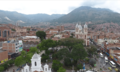
Center of the city
-
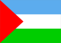
Flag of Bello
-
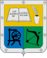
Seal of Bello
-
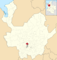
Location of Bello in Antioquia
