Ben Avon Heights, Pennsylvania facts for kids
Quick facts for kids
Ben Avon Heights, Pennsylvania
|
|
|---|---|
|
Borough
|
|

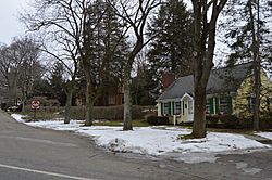
Houses on Lynton Lane
|
|
| Etymology: Scottish for "hill by the waters" |
|

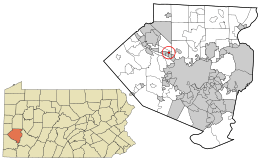
Location in Allegheny County and the U.S. state of Pennsylvania.
|
|
| Country | United States |
| State | Pennsylvania |
| County | Allegheny |
| Incorporated | 1913 |
| Area | |
| • Total | 0.17 sq mi (0.45 km2) |
| • Land | 0.17 sq mi (0.45 km2) |
| • Water | 0.00 sq mi (0.00 km2) |
| Elevation | 1,135 ft (346 m) |
| Population
(2020)
|
|
| • Total | 400 |
| • Density | 2,298.85/sq mi (889.56/km2) |
| Time zone | UTC-5 (EST) |
| • Summer (DST) | UTC-4 (EDT) |
| ZIP code |
15202
|
| Area code(s) | 412 |
| FIPS code | 42-05520 |
| School District | Avonworth |
Ben Avon Heights is a small town, called a borough, in Allegheny County, Pennsylvania, United States. It sits on a hill overlooking the Ohio River. This borough is about 9 miles (14 km) from the city of Pittsburgh. In 2020, about 400 people lived there. Ben Avon Heights is part of the larger Pittsburgh metropolitan area.
Contents
History of Ben Avon Heights
How Ben Avon Heights Started
Before 1906, the land where Ben Avon Heights is now was mostly farmland. It belonged to two people, Samuel Taylor and John Wilson. In 1910, a man named Walter Pringle Fraser from nearby Ben Avon bought 84 acres (34 hectares) of the old Taylor farm.
He used 40 acres (16 hectares) to build the Ben Avon Country Club and a golf course. The other 44 acres (18 hectares) were set aside for new homes. This new neighborhood was named Ben Avon Heights. Like its neighbor, Ben Avon Heights became a popular spot for people from Pittsburgh. They wanted summer homes away from the busy city. The borough officially became a town in 1913.
Growing Over the Years
The Ben Avon Country Club closed in 1917. Its land was then divided into smaller pieces for more houses. In 1920, the Shannopin Country Club opened. Its main building is in Ben Avon Heights, and its golf course is in Kilbuck Township. This club is the only business property in Ben Avon Heights.
In the early 1930s, John I. Thompson bought part of the original John Wilson Farm. This land was in Kilbuck Township. He turned this farmland into another area for homes, called the Thompson Plan. In 1936, Ben Avon Heights added the Thompson Plan to its area. This set the boundaries of Ben Avon Heights as they are today.
Today, Ben Avon Heights has 148 homes. It also has a community park and the clubhouse for the Shannopin Country Club.
Geography of Ben Avon Heights
Ben Avon Heights is located at 40°30′43″N 80°4′28″W / 40.51194°N 80.07444°W.
Size and Elevation
The United States Census Bureau says the borough covers about 0.2 square miles (0.45 square kilometers). All of this area is land. The average height of Ben Avon Heights is about 1,135 feet (346 meters) above sea level.
Neighboring Areas
Ben Avon Heights shares its borders with two other places. To the north, east, and west, it borders Kilbuck Township. To the south, it borders the town of Avalon.
Population of Ben Avon Heights
How Many People Live Here?
The number of people living in Ben Avon Heights has changed over the years. Here is a look at the population from different census counts:
| Historical population | |||
|---|---|---|---|
| Census | Pop. | %± | |
| 1920 | 130 | — | |
| 1930 | 265 | 103.8% | |
| 1940 | 393 | 48.3% | |
| 1950 | 394 | 0.3% | |
| 1960 | 431 | 9.4% | |
| 1970 | 443 | 2.8% | |
| 1980 | 398 | −10.2% | |
| 1990 | 373 | −6.3% | |
| 2000 | 392 | 5.1% | |
| 2010 | 371 | −5.4% | |
| 2020 | 400 | 7.8% | |
| Sources: | |||
In 2000, there were 392 people living in Ben Avon Heights. The population density was about 2,329 people per square mile (899 people per square kilometer). The median age of people in the borough was 39 years old.
See also
 In Spanish: Ben Avon Heights para niños

