Bethania Historic District facts for kids
|
Bethania Historic District
|
|

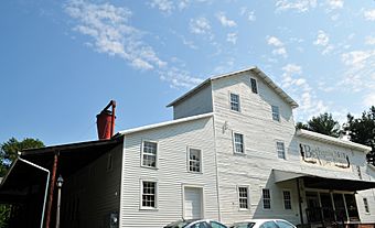
Bethania Mill
|
|
| Location | Bethania, North Carolina |
|---|---|
| Area | 500 acres (2.0 km2) |
| Built | 1759 (original) 1750 (increase) |
| Architectural style | Bungalow/craftsman |
| NRHP reference No. | 76001321 (original) 91000346 (increase) |
Quick facts for kids Significant dates |
|
| Added to NRHP | May 03, 1976 |
| Boundary increase | March 25, 1991 |
| Designated NHLD | August 7, 2001 |
The Bethania Historic District is a very special place in Bethania, North Carolina. It's like stepping back in time! This district is a rare example of an old Moravian village. It was carefully planned and founded way back in 1759. Even today, you can still see the original layout of the roads and how the land was used.
This area was officially named a National Historic Landmark in 2001. It covers about 500 acres (about 2 square kilometers). This makes it the largest historic district in Forsyth County.
Discovering Bethania's History
Bethania is located near Winston-Salem, North Carolina. It's in the northwestern part of Forsyth County. Long ago, this land was sold to members of the Moravian Church. They called this large area "Wachovia."
In 1753, the Moravians set up a temporary community. They called it Bethabara. Their plan was to build permanent towns elsewhere on the Wachovia land.
How Bethania Was Planned
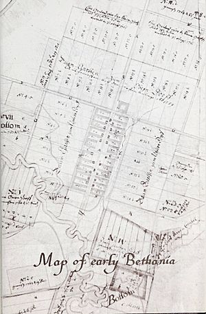
Bethania was the very first permanent settlement they built. It was laid out in 1759 by a man named Christian Philip Gottlieb Reuter. He planned the town on about 2,000 acres of the huge Wachovia tract.
Reuter's plan was very clever. He designed a compact village close to Muddy Creek. The areas for farming were near the creek and on the higher ground. The settlement had four main sections. Each section was divided into 24 smaller pieces of land.
These sections were:
- Residential Lots: Where people would build their homes.
- Orchard Lots: For growing fruit trees.
- Bottom Lots: Low-lying land near the creek, good for certain crops.
- Upland Lots: Higher ground, also used for farming.
A network of roads was also planned. These roads helped people get to all their different pieces of land. Over time, as the area became safer, the town grew. New lots were added even into the 1800s.
Bethania Today
It's amazing that the original road layout is still visible today. You can see how the community was first designed. The main roads include Main Street, Bethania Road, and Bethania-Rural Hall Road. Loesch's Lane and Town Lot Drive also serve the village center.
Many of the old farming areas are still used for agriculture. However, some have become new neighborhoods. Some buildings along Main Street are very old, dating back to the 1760s and 1770s. These show how the town first developed.
If you visit Bethania, there's a visitor center. They offer a map for self-guided walking tours. It's a great way to explore this historic village!
 | Isaac Myers |
 | D. Hamilton Jackson |
 | A. Philip Randolph |


