
Bethungra facts for kids
Quick facts for kids BethungraNew South Wales |
|
|---|---|

Entering Bethungra
|
|

Bethungra
Location in New South Wales
|
|
| Population | 414 (2011 census) |
| Postcode(s) | 2590 |
| Elevation | 310 m (1,017 ft) |
| Location |
|
| LGA(s) | Junee Shire |
| County | Clarendon |
| State electorate(s) | Cootamundra |
| Federal Division(s) | Riverina |
Bethungra is a small place in the Junee Shire area of New South Wales, Australia. It's located in the South West Slopes region, which is known for its rolling hills and farming land. Bethungra is found along the Olympic Highway, about 13 kilometres northeast of Illabo and 24 kilometres southwest of Cootamundra.
The Bethungra Post Office first opened its doors a long time ago, on 1 December 1875. This shows that people have lived and worked in Bethungra for many years.
Exploring Bethungra's Railway History
Bethungra has an interesting connection to trains. A railway station used to be in the town from 1878 until the 1980s. It was an important stop for people and goods travelling by train.
The Amazing Bethungra Spiral
Just north of Bethungra, you can find a very special part of the railway called the Bethungra Spiral. Imagine a corkscrew or a giant loop for trains! This unique railway design was built between 1941 and 1946. It's part of the Main South railway line. The spiral was created to make the train journey easier by reducing how steep the tracks were. This was especially important when the railway line was made bigger with more tracks.
Images for kids
-
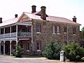
The Bethungra Hotel, also known as Hotel Shirley.
-
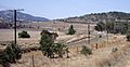
A view of the Bethungra Spiral, a unique railway design.
-
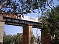
An overpass located just south of the Bethungra Spiral.


| Preceding station | NSW Main lines | Following station | ||
|---|---|---|---|---|
|
Template:NSW Country lines stations
toward Template:NSW Country lines stations
|
Template:NSW Country lines lines |
Template:NSW Country lines stations
toward Template:NSW Country lines stations
|
