Big Molly Upsim Lake facts for kids
Quick facts for kids Big Molly Upsim Lake |
|
|---|---|

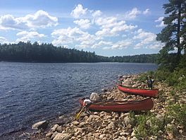
Canoeing on Big Molly Upsim Lake and stopping on the northern Island.
|
|
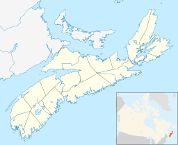
| Location | Annapolis County, Nova Scotia |
| Coordinates | 44°37′N 65°07′W / 44.62°N 65.11°W |
| Basin countries | Canada |
Big Molly Upsim Lake is a beautiful lake located in Nova Scotia, a province in southeastern Canada. It's about 800 kilometers (or 500 miles) east of Canada's capital city, Ottawa.
This lake sits 186 meters (about 610 feet) above sea level. It covers an area of 5.2 square kilometers (about 2 square miles). The lake stretches 5.8 kilometers (3.6 miles) from north to south and 3.5 kilometers (2.2 miles) from east to west.
Exploring Big Molly Upsim Lake
Big Molly Upsim Lake is a great place to explore nature. The area around the lake is mostly covered by thick forests. Not many people live here, so it's a very quiet and natural spot.
Nearby Waters
Big Molly Upsim Lake is connected to several other waterways and lakes. These connections help keep the lake healthy and full of life.
Here are some of the rivers and streams that flow into or out of the lake:
- Curl Hole
- Kelly Brook
- Lake Fredericks Brook
And here are some of the other lakes nearby:
- Fourth Molly Upsim Lakes
- Kelly Lake
- Little Cranberry Lake
- Little Molly Upsim Lake
- Little Pine Lake
- Long Lake
- Nineteen Mile Lake
- North Lake
- Pine Lake
Weather and Environment
The area around Big Molly Upsim Lake has a climate that's a mix of northern forests and warmer zones. This is called a hemiboreal climate.
The average temperature throughout the year is about 5°C (41°F). The warmest month is July, when temperatures average 18°C (64°F). The coldest month is January, with an average temperature of -12°C (10°F).
The area gets a lot of rain and snow, about 1,919 millimeters (75 inches) each year. December is usually the wettest month, while August is the driest.
 | John T. Biggers |
 | Thomas Blackshear |
 | Mark Bradford |
 | Beverly Buchanan |


