Bingham Farms, Michigan facts for kids
Quick facts for kids
Bingham Farms, Michigan
|
|
|---|---|
|
Village
|
|
| Village of Bingham Farms | |

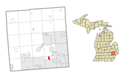
Location within Oakland County
|
|
| Country | United States |
| State | Michigan |
| County | Oakland |
| Township | Southfield |
| Incorporated | 1955 |
| Area | |
| • Total | 1.21 sq mi (3.15 km2) |
| • Land | 1.21 sq mi (3.15 km2) |
| • Water | 0.00 sq mi (0.00 km2) |
| Elevation | 712 ft (217 m) |
| Population
(2020)
|
|
| • Total | 1,124 |
| • Density | 925.86/sq mi (357.34/km2) |
| Time zone | UTC-5 (Eastern (EST)) |
| • Summer (DST) | UTC-4 (EDT) |
| ZIP code(s) |
48025
|
| Area codes | 248 |
| FIPS code | 26-08460 |
| GNIS feature ID | 2398123 |
Bingham Farms is a small village in Oakland County, Michigan. It's a northern suburb located about 20 miles (32 km) northwest of downtown Detroit. In 2020, about 1,124 people lived there.
Contents
History of Bingham Farms
Early Settlement and Growth
Bingham Farms was first settled in 1823 by John Daniels. He came from Rutland, Vermont. The area was part of what became Southfield Township in 1830. For a long time, the settlement stayed small and quiet.
Things started to change when Telegraph Road was built through the area in 1928. This road made it easier to travel and connect with other places.
Becoming a Village
In the early 1950s, people in the southern part of Southfield Township wanted to make the whole township a city. To keep their unique identity, the smaller settlements in the northern part, like Bingham Farms, decided to become villages. This helped them avoid being taken over by larger cities.
Bingham Farms officially became a village on October 4, 1955. It was named after an important family who had lived there since 1880. To keep the area from becoming too developed, all the roads in the village remained unpaved until 1984.
Geography of Bingham Farms
Bingham Farms covers a total area of about 1.21 square miles (3.15 square kilometers). All of this area is land. There are no large bodies of water within the village limits.
Population and People
How Many People Live Here?
The number of people living in Bingham Farms has changed over the years:
| Historical population | |||
|---|---|---|---|
| Census | Pop. | %± | |
| 1960 | 394 | — | |
| 1970 | 566 | 43.7% | |
| 1980 | 529 | −6.5% | |
| 1990 | 1,001 | 89.2% | |
| 2000 | 1,030 | 2.9% | |
| 2010 | 1,111 | 7.9% | |
| 2020 | 1,124 | 1.2% | |
| U.S. Decennial Census | |||
Facts from the 2010 Census
In 2010, there were 1,111 people living in Bingham Farms. These people lived in 527 households. About 332 of these were families. The village had about 918 people per square mile (354 per square kilometer).
Most residents (85.2%) were White. About 7.6% were African American, and 4.4% were Asian. A small number of people were Native American or from other backgrounds. About 0.9% of the population was Hispanic or Latino.
The average age of people in the village was 59.7 years old. About 15.2% of residents were under 18. Many residents, 39.1%, were 65 years or older. There were slightly more females (52.7%) than males (47.3%).
Education in Bingham Farms
Students in Bingham Farms attend schools in the Birmingham City School District. Bingham Farms Elementary School is located right in the village.
Some students from the French School of Detroit (FSD) also attend classes here. FSD middle school students go to Berkshire Middle School in nearby Beverly Hills. FSD elementary students attend classes at Bingham Farms Elementary School.
Business in Bingham Farms
The Bingham Farms Office District is on the east side of Telegraph Road. It has many two- and four-story office buildings. One important business located here is the headquarters of Global Commercial Credit.
See also
 In Spanish: Bingham Farms para niños
 | John T. Biggers |
 | Thomas Blackshear |
 | Mark Bradford |
 | Beverly Buchanan |


