Birriwa, New South Wales facts for kids
Quick facts for kids BirriwaNew South Wales |
|
|---|---|

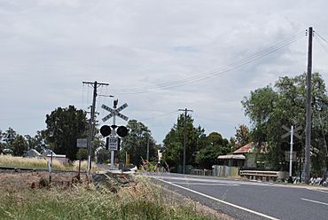
Level crossing at Birriwa
|
|
| Postcode(s) | 2844 |
| Location | |
| LGA(s) | Mid-Western Regional Council |
| State electorate(s) | Orange |
| Federal Division(s) | Parkes |
Birriwa is a small place, or locality, in central New South Wales, Australia. It is located in the central west of New South Wales. You can find Birriwa on the Castlereagh Highway. It sits between the towns of Gulgong and Dunedoo.
Birriwa's Location
Birriwa is part of the Mid-Western Regional Council area. It is about 329 kilometers northwest of Sydney, Australia's largest city. The larger town of Dubbo is about 109 kilometers to the east. Birriwa is also close to Gulgong, which is 32 kilometers north, and Dunedoo, which is 19 kilometers south.
Birriwa and the Railway
A railway line, called the Gwabegar railway line, reached Birriwa a long time ago. A train station opened there in 1909. Today, passenger trains no longer stop at Birriwa. However, the railway is still important for the area.
The Grain Silo
A very large building called a grain silo is still used in Birriwa. This silo stores grain from local farms. It is located where the railway line crosses the Castlereagh Highway. This crossing is known as a level crossing. Trains still use the line to carry grain from the silo.
 | Aaron Henry |
 | T. R. M. Howard |
 | Jesse Jackson |


