Bison, Oklahoma facts for kids
Quick facts for kids
Bison, Oklahoma
|
|
|---|---|

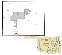
Location in Garfield County and the state of Oklahoma
|
|
| Country | United States |
| State | Oklahoma |
| County | Garfield |
| Area | |
| • Total | 1.06 sq mi (2.74 km2) |
| • Land | 1.06 sq mi (2.74 km2) |
| • Water | 0.00 sq mi (0.00 km2) |
| Elevation | 1,217 ft (371 m) |
| Population
(2020)
|
|
| • Total | 56 |
| • Density | 52.88/sq mi (20.41/km2) |
| Time zone | UTC-6 (Central (CST)) |
| • Summer (DST) | UTC-5 (CDT) |
| ZIP code |
73720
|
| Area code(s) | 580 |
| FIPS code | 40-06350 |
| GNIS feature ID | 2629907 |
Bison is a small community in Garfield County, Oklahoma, United States. It is known as an "unincorporated community" and a "census-designated place" (CDP). This means it's a specific area that the government counts for population, even though it doesn't have its own city government. In 2020, about 56 people lived there. Bison is located right on US Highway 81.
Contents
History of Bison
How Bison Got Its Name
The community of Bison was named after Buffalo Springs. This was a famous old stop for stagecoaches and a watering hole. It was located on the historic Chisholm Trail, which was a path used to move cattle. Buffalo Springs is about a mile north of where Bison is today.
Early Buildings and Businesses
Bison has a strong Catholic community. St. Joseph's church was built in 1909. A two-story brick school building followed in 1911. It was first run by the Sisters of the Divine Providence. Later, the Adorers of the Blood of Christ took over from 1934.
Bison's economy has always been based on farming and oil. There are oil wells on many farms. You can also see large grain elevators owned by companies like Bison Cooperative Association, Star Mill, and Burrus Mill.
The Bison State Bank was open from 1900 until 1933. It closed during a very difficult economic time known as the Great Depression.
The Hotel Woodring was started in 1900 by Irvin and Ella Woodring. Their son, Irvin "Bertie" Woodring, later had the Enid Woodring Regional Airport named after him. Bison got its own post office on August 31, 1901. The Bison Mercantile Company was a grocery store started in 1900. It operated until 1958 when the Bison Cooperative Association bought it. The co-op itself was started in 1920. That same year, Oklahoma Gas & Electric brought electricity to the town.
Geography of Bison
Bison is located in the southern part of Garfield County. It sits on the west side of US Highway 81. This highway goes north about 14 miles to Enid, which is the main city of the county. It goes south about 6 miles to Hennessey.
According to the U.S. Census Bureau, the Bison CDP covers an area of about 2.74 square kilometers (1.06 square miles). All of this area is land.
Bison's Climate
Bison experiences a climate with warm summers and mild winters. The hottest month is usually August, and the coldest is January. The area gets a good amount of rain, especially in the spring and early summer. Snowfall is light and mostly happens in the winter months.
Population of Bison
| Historical population | |||
|---|---|---|---|
| Census | Pop. | %± | |
| 2020 | 56 | — | |
| U.S. Decennial Census | |||
As of the 2020 census, the population of Bison was 56 people. This shows how many people live in this small community.
Education in Bison
Children in Bison attend schools that are part of the Waukomis Public Schools district.
See also
 In Spanish: Bison (Oklahoma) para niños
 | May Edward Chinn |
 | Rebecca Cole |
 | Alexa Canady |
 | Dorothy Lavinia Brown |

