
Black Jungle Conservation Reserve facts for kids
Quick facts for kids Black Jungle / Lambells Lagoon Conservation ReserveBlack Jungle and Lambells Lagoon, Northern Territory |
|
|---|---|
|
IUCN Category VI (Managed Resource Protected Area)
|
|

Black Jungle / Lambells Lagoon Conservation Reserve
Location in Northern Territory
|
|
| Established | 25 March 1986 |
| Area | 49.51 km2 (19.1 sq mi) |
| Managing authorities | Parks and Wildlife Commission of the Northern Territory |
| See also | Protected areas of the Northern Territory |
The Black Jungle Conservation Reserve is a special protected area in the Northern Territory of Australia. It's located near Darwin, the capital city. This area is very different from the rural places further south in Australia.
Before 1950, this region was mostly wild tropical savanna. It had small patches of monsoon rainforest and swampy areas. For thousands of years, it stayed this way, looked after by the Aboriginal people. They hunted, gathered food, and used fire to manage the land.
Black Jungle Conservation Reserve is part of a bigger system called the Adelaide River Coastal Floodplain. This system includes other important places like Lambells Lagoon, Fogg Dam, and Djukbinj National Park. All these areas have different types of wetlands. They are important on a global scale because of their unique features.
These wetland homes are super important for nature. They protect many rare and endangered animals and plants. Huge groups of waterbirds live here, and it's a breeding ground for saltwater crocodiles. It even has the highest number of water pythons and dusky rats found anywhere in the world! The wetlands are also very special to the traditional Aboriginal owners. They are places for ceremonies, stories, and have always provided food, medicine, and other resources. Some parts of these areas also have historical sites from World War II.
Contents
What is the Black Jungle Conservation Reserve?
The Black Jungle and Lambells Lagoon Conservation Reserves are two special areas connected by a narrow strip of trees. They are next to the Fogg Dam Reserve. Together, they form part of the important Adelaide River Coastal Floodplain.
The Black Jungle part of the reserve has rainforest patches fed by natural springs. These springs keep the rainforest wet all year, even in the dry season. This helps lots of wildlife, including endangered species, to survive. It's also a key breeding spot for wetland birds and saltwater crocodiles.
One amazing fact is that the highest number of magpie geese breeding in the world has been seen near Black Jungle swamp. This makes the reserve extra important, especially during the wet season.
-
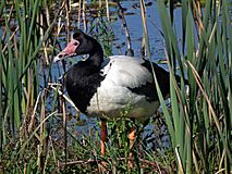
Magpie goose - Anseranus semipalmata
-
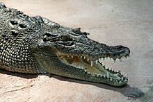
Estuarine crocodile – Crocodylus porosus
-
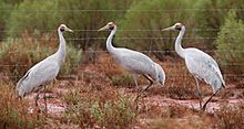
Brolga - Grus Rubicundas


Where is Black Jungle Conservation Reserve?
The Black Jungle Conservation Reserve is about 62 kilometers (38 miles) southeast of Darwin. It's located in an area called the Hundred of Hutchison.
Most people cannot visit the reserve. Access is usually only allowed with a special permit. This is mainly for scientific reasons, like research or collecting crocodile eggs.
What is the Climate Like?
This part of the Northern Territory has a very distinct climate. It has a long dry season from April to November. Then, there's a shorter wet season from December to March.
About 1380 millimeters (54 inches) of rain falls each year. Most of this rain happens in January and February. Temperatures are quite steady throughout the year. Daytime temperatures range from about 31°C (88°F) in July to 35°C (95°F) in October. Nighttime temperatures are cooler, from 15°C (59°F) in July to 23°C (73°F) in January and February. The air gets very humid from September and stays that way during the wet season.
What Plants Grow Here?
The area is mostly open woodland savanna. This means it has scattered trees and lots of grass. But there are also pockets of wet monsoon rainforest and swampy areas with melaleuca trees. Some parts are covered mainly by grass and sedges.
The main trees in the woodland are two types of Eucalyptus. A key feature of the wet monsoon rainforests is that they always have water, thanks to permanent creeks and springs. These areas are full of evergreen trees and palms. The trees in these rainforest patches can grow up to 30 meters (98 feet) tall. Below them, there's a thick layer of smaller plants like ferns and sedges.
Who Owns and Uses the Land?
The Black Jungle/Lambells Lagoon Conservation Reserve is part of the Adelaide River Coastal Floodplain. This is a large freshwater system that gets flooded during the wet season. It also has a major tidal river running through it.
Almost half of the Adelaide River floodplain is used for pastoral leases, which means it's rented out for grazing animals. About 25% of the floodplain is set aside for conservation. This includes places like Fogg Dam, Lambells Lagoon, Black Jungle, and Djukbinj National Park.
A Look Back in Time
Before Europeans arrived, Aboriginal people traditionally managed this region. They used methods like "fire-stick farming" to clear land and help new plants grow. Aboriginal people were known for their deep connection to the land and their commitment to caring for it.
The name "Black Jungle" first appeared on a map in 1910. This area, often called "The Jungle," was part of Koolpinyah Station. This large cattle station was owned by the Herbert brothers. Their father, Charles Edward Herbert, was an important judge and politician in the Northern Territory.
The Herbert brothers started Koolpinyah Station in 1908. They used it for "mixed farming," which meant raising different animals and growing various crops. They hunted wild cattle and shared food and money with Aboriginal elders, who were also allowed to camp on the property.
In the 1980s and 1990s, the government looked for land suitable for farming. They decided to swap some land to create conservation reserves. This is how Malacca Swamp and Black Jungle became protected areas. They were taken from Koolpinyah pastoral station to be set aside for nature.
Protecting Nature
Many areas in the Top End of the Northern Territory are protected for conservation. This includes Black Jungle, Malacca Swamp, and the mangroves along the Litchfield waterways. Large areas are also protected to keep water sources clean.
The conservation of these areas wasn't just about protecting the landscape. It was also about protecting the underground water supplies, called aquifers. When too much groundwater is taken for farming, it can harm the freshwater springs and rainforest patches like those at Black Jungle Swamp.
The Northern Territory Parks and Wildlife Commission manages Black Jungle. It was established as a conservation area in 1986. As mentioned, public access is usually only allowed with a permit for scientific research or crocodile egg harvesting. Sometimes, people try to enter the reserve without permission, which can damage fences and gates.
Working Together: Joint Management
The Black Jungle area is part of an Indigenous Land Use Agreement. This means the land is managed jointly by the Northern Territory Government Parks and Wildlife Commission and the traditional Aboriginal owners. This joint management approach has been used in the Territory since 1981 to look after parks.
Laws were passed in 2003 and 2005 to help settle land claims and set up principles for joint management in many parks and reserves. This ensures that the knowledge and traditions of Aboriginal people are included in caring for these special places.

Rare and Special Species
The Black Jungle Reserve is recognized for its natural importance. It's listed on the Register of the National Estate. Four special species, including two that are listed as threatened globally, live here:
Luisia teretifolia, Gaudich, Orchid
This orchid is considered vulnerable. There are fewer than 1000 mature plants, and they grow in a small area. This orchid grows in clumps with thin stems up to 30 cm (12 inches) long. Its roots are thick, like cords. It has small green or yellow-green flowers with a dark red center, about 1 cm (0.4 inches) wide. It usually flowers from November to December.
This orchid grows on the edges of monsoon rainforests where there is enough light. It has only been found in a few places on the mainland, including within the Black Jungle Conservation Reserve.

Ptychosperma bleeseri Burret, Darwin Palm
This palm is listed as endangered under Australian law. It is also specially protected under Territory laws.
The Darwin Palm is found in only eight small rainforest patches southeast of Darwin. Three of these patches are inside the Black Jungle Conservation Reserve. These palm areas are also listed as important on the Register of the National Estate. The other patches are on private or leased land.
The Darwin Palm is slender and can grow up to 12 meters (39 feet) tall. It has multiple green trunks and feathery fronds up to 1.5 meters (5 feet) long. It flowers in the dry season and produces fruit between August and December.
This palm faces threats from weeds and damage by wild animals like pigs, which eat the young plants. Changes in water quality and quantity from nearby land use also threaten it. Intense fires can also kill adult plants and stop new ones from growing.
Typhonium johnsonianum A. Hay and S.M. Taylor
This plant is also listed as vulnerable. It is known from only two specimens found in the Black Jungle Reserve in the 1990s. This means it's very rare and only found in this specific area.
It grows in wet monsoon forests with high water levels during the wet season. However, conditions change a lot in the dry season. Fires could be a serious threat to this plant because it lives in such a small area. It is found in open, grassy clearings between different types of trees, in sandy soil that gets flooded seasonally.
Nososticta koolpinyah, Koolpinyah Threadtail Dragonfly
This dragonfly is found only in Australia. It lives in places like Black Jungle, Koolpinyah Station, and Melville Island in the Northern Territory. It's considered a rare species that lives near freshwater streams and on land.
Threats to this dragonfly include farming, industry, and mining. These activities are believed to harm the dragonfly's natural home.
