
Blackdown Tableland National Park facts for kids
Quick facts for kids Blackdown Tableland National ParkQueensland |
|
|---|---|
|
IUCN Category II (National Park)
|
|

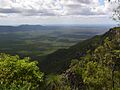
View from the top of Blackdown Tableland
|
|

Blackdown Tableland National Park
Location in Queensland
|
|
| Nearest town or city | Dingo |
| Established | 1991 |
| Area | 320 km2 (123.6 sq mi) |
| Managing authorities | Queensland Parks and Wildlife Service |
| Website | Blackdown Tableland National Park |
| See also | Protected areas of Queensland |
The Blackdown Tableland National Park is a special place in Queensland, Australia. It is a national park found in the Central Highlands Region. This park protects a unique natural area that rises high above the surrounding plains.
Contents
Exploring Blackdown Tableland
Blackdown Tableland National Park is located in Central Queensland. It is about 576 kilometers (358 miles) northwest of Brisbane. The park is known for its amazing landscape. You can find deep gorges, beautiful waterfalls, and many different kinds of plants here.
What is a Tableland?
The Blackdown Tableland is like a giant, flat-topped mountain. It is a sandstone plateau that rises suddenly about 900 meters (2,950 feet) from the flat land below. This makes it look like a huge table!
Many creeks flow across the Tableland. Over time, these creeks have carved out deep gorges and created stunning waterfalls. The most famous waterfall is called Rainbow Falls, or Gudda Gumoo. Water drops about 40 meters (130 feet) here, creating a spectacular sight.
Some creeks get their water from rain. These can sometimes dry up. Other creeks are fed by underground springs, so they always have at least a little water flowing. The park is in the northeastern part of Queensland's sandstone area.
How the Land Was Formed
The Tableland sits where three mountain ranges meet: the Shotover, Expedition, and Dawson Ranges. The land here has been pushed and folded over millions of years. This created the hills and valleys you see today.
A Look at History
The Blackdown Tableland is the traditional home of the Ghungalu people. They are the original owners and caretakers of this land. You can still find their ancient rock art in the park. This art tells stories and shows how they lived long ago.
The Wadja language is an Aboriginal language from Central Queensland. The area where Wadja was spoken includes the Blackdown Tablelands. It also covers places like the Aboriginal Shire of Woorabinda and the Central Highlands Region.
Climate and Nature
The top of the Tableland has cooler weather than the plains below. This special climate helps many unique plants and animals to live here. You can find open forests, heathlands, and ferns. Some of these plants and animals are found nowhere else in the world!
Parts of the eastern Tableland get a lot of rain, about 1,500 millimeters (59 inches) each year. Sometimes, thick fog can cover the plateau, making it feel mysterious.
Visiting the Park
Blackdown Tableland National Park offers several things to do for visitors.
- Camping: You can camp at Munall campground. There is a fee to camp here.
- Walking Tracks: There are many walking tracks. These paths lead to amazing lookouts, important heritage sites, and beautiful creeks.
- Picnic Areas: You can enjoy a picnic at the Yaddamen Dhina lookout.
Getting There
For a long time, it was hard to get to the Blackdown Tableland. But in 1969, a road was built, making it much easier. To reach the park, you turn off the Capricorn Highway about 11 kilometers (7 miles) west of Dingo.
Images for kids
-
View from the top of Blackdown Tableland
See also
 In Spanish: Parque nacional Meseta Blackdown para niños
