Blacksville, Georgia facts for kids
Quick facts for kids
Blacksville, Georgia
|
|
|---|---|

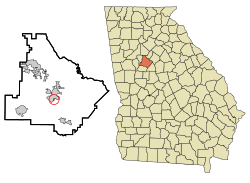
Location in Henry County and the state of Georgia
|
|
| Country | United States |
| State | Georgia |
| County | Henry |
| Area | |
| • Total | 0.1 sq mi (0.2 km2) |
| • Land | 0.1 sq mi (0.2 km2) |
| • Water | 0 sq mi (0 km2) |
| Elevation | 886 ft (270 m) |
| Population
(2000)
|
|
| • Total | 4 |
| • Density | 40/sq mi (20/km2) |
| Time zone | UTC-5 (Eastern (EST)) |
| • Summer (DST) | UTC-4 (EDT) |
| FIPS code | 13-08340 |
| GNIS feature ID | 0331179 |
Blacksville is a small, unincorporated community in Henry County, Georgia, United States. An unincorporated community means it's a place with a shared identity but no official local government.
In the year 2000, Blacksville was counted as a census-designated place (CDP). A CDP is a special area that the U.S. Census Bureau defines for gathering statistics, even if it's not an official town. At that time, only four people lived there. By the 2010 census, it was no longer listed as a CDP.
Blacksville got its name from the Black family, who were early settlers in the area. They were pioneers who moved to the village of McDonough, Georgia. The high school for Black students in Henry County during the segregation era was located in Blacksville. Today, that building is used as Henry County Middle School. Over time, much of the Blacksville community became part of the nearby city of McDonough.
Where is Blacksville Located?
Blacksville is a very small area. According to the United States Census Bureau, it covers about 0.1 square miles (0.2 square kilometers) of land. There is no water area within Blacksville.
Main Roads Nearby
Several important roads pass through or near Blacksville. These roads help people travel to and from the community.
 Interstate 75
 U.S. Highway 23
 Georgia State Route 20
 Georgia State Route 42
 Georgia State Route 81
 Georgia State Route 155
 Georgia State Route 401
Who Lives in Blacksville?
Demographics is the study of populations. It looks at things like how many people live somewhere, their ages, and how households are set up.
| Historical population | |||
|---|---|---|---|
| Census | Pop. | %± | |
| 1980 | 1,521 | — | |
| 1990 | 1,112 | −26.9% | |
| 2000 | 4 | −99.6% | |
| source: | |||
While many people still live in the general area that was once known as Blacksville, the official count for the CDP changed a lot. In 1980, 1,521 people lived there, which dropped to 1,112 in 1990. By the year 2000, only 4 people were recorded as living in the specific CDP area.
In 2000, there was only one household and one family living in the CDP. This household was a married couple with children under 18. The average household size was 4 people.
The ages of the people living there in 2000 were:
- 25% were under 18 years old.
- 50% were between 25 and 44 years old.
- 25% were between 45 and 64 years old.
The median age was 28 years. This means half the people were younger than 28 and half were older.
The median income for the household in 2000 was $53,750. This means that half of the households earned more than this amount, and half earned less.
See also
 In Spanish: Blacksville (Georgia) para niños

