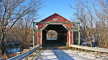
Blanche River (Bécancour River tributary, Daveluyville) facts for kids
Quick facts for kids Blanche River |
|
|---|---|

The Blanche river at the Étienne-Poirier bridge
|
|
| Native name | Rivière Blanche |
| Country | Canada |
| Province | Quebec |
| Region | Centre-du-Québec |
| MRC | Nicolet-Yamaska Regional County Municipality, Bécancour Regional County Municipality |
| Municipality | Sainte-Eulalie, Aston-Jonction, Saint-Wenceslas, Saint-Léonard-d'Aston, Saint-Célestin, Bécancour |
| Physical characteristics | |
| Main source | Swampy area of Rang des Épinettes Sainte-Eulalie 91 m (299 ft) 46°08′06″N 72°10′34″W / 46.1351196°N 72.1762335°W |
| River mouth | Bécancour River Daveluyville 24 m (79 ft) 46°17′29″N 72°23′04″W / 46.2914793°N 72.3844843°W |
| Length | 51.1 km (31.8 mi) |
| Basin features | |
| Progression | Bécancour River, St. Lawrence River |
| Tributaries |
|
The Blanche River is a waterway located in the Centre-du-Québec region of Quebec, Canada. It flows on the south side of the famous St. Lawrence River. This river passes through several towns and areas. These include Sainte-Eulalie, Aston-Jonction, Saint-Wenceslas, Saint-Léonard-d'Aston, and Saint-Célestin. It also flows through the city of Bécancour. The river was once known as the "Saint-Wenceslas River."
Contents
Where is the Blanche River?
The Blanche River mainly flows north through farms and some forest areas. It is on the south side of the St. Lawrence River.
River's Starting Point
The river begins in a swampy area. This marsh is about 2.3 kilometers long and 1.7 kilometers wide. It is located near Sainte-Eulalie and Daveluyville. This swamp is the source of the river's water. Several small streams, like the Paquin stream, help drain this area.
How Long is the Blanche River?
The Blanche River stretches for about 51.1 kilometers (31.8 miles). As it flows, the river drops about 67 meters (220 feet) in height. This drop creates a gentle slope for the water to move.
First Part of the River's Journey
From its start, the Blanche River flows through farmland.
- For 0.75 km, it goes north towards Autoroute 20.
- Then, it turns northeast for 0.9 km in Sainte-Eulalie.
- It flows west for 2.5 km, crossing the Route des Pins.
- For 3.3 km, it continues west through Aston-Jonction.
- It then turns southwest for 2.75 km.
- Finally, it flows northwest for 3.9 km. During this part, it crosses a railroad and passes near the village of Saint-Wenceslas.
Middle Part of the River's Journey
After passing Saint-Wenceslas, the river continues through more farmlands.
- It flows southwest for 2.7 km, crossing the main road and going under Autoroute 55.
- It continues southwest for 1.3 km, where the Fourchu stream joins it.
- For 0.4 km, it goes south, meeting the Bruneau brook.
- It turns west for 0.3 km.
- Then, it flows west for 4.0 km through a wooded area.
- For 1.5 km, it goes westward, meeting the Joanny stream.
- It turns north for 2.0 km, reaching Route Saint-Joseph in Saint-Célestin.
- It continues north for 1.4 km, where the Bédard stream flows in.
- For 0.9 km, it flows north, meeting the Ludger-Carignan stream.
- It goes northward for 3.2 km, crossing Autoroute 55 again.
- Finally, it flows eastward for 200 meters to the Étienne-Poirier covered bridge.
Last Part of the River's Journey
After the Étienne-Poirier covered bridge, the Blanche River continues its journey.
- It flows north for 1.8 km, meeting the Vouligny stream.
- It turns northwest for 2.2 km, then north for 0.8 km.
- For 0.6 km, it flows northward, where the Gilbert stream joins it.
- It continues north for 3.2 km, crossing a road.
- For 1.0 km, it flows north, meeting the Jacques-Leblanc stream.
- It goes north, then northwest for 3.6 km.
- For 3.7 km, it flows north, then northeast through a forest.
- It continues northeasterly for 2.0 km, reaching boul. Danube.
- Finally, it flows northeast for 230 meters. This is where the Blanche River ends, flowing into the Bécancour River in Bécancour.
Neighboring Rivers
The Blanche River is surrounded by other important rivers:
- To the northeast, there is the Bécancour River.
- To the southwest, you can find the Nicolet River.
- To the east, there is the Portage River, which also flows into the Bécancour River.
What's in a Name?
The name "Rivière Blanche" means "White River" in French. Before it was called the Blanche River, people sometimes called it the "Saint-Wenceslas River" or "Wenceslas River." The official name "Rivière Blanche" was confirmed on November 27, 1979. This was done by the Commission de toponymie du Québec, which is like a special group that names places in Quebec.
 | Kyle Baker |
 | Joseph Yoakum |
 | Laura Wheeler Waring |
 | Henry Ossawa Tanner |

