
Bloomfield Run facts for kids
Quick facts for kids Bloomfield Run |
|
|---|---|


|
|
| Other name(s) | Tributary to Oil Creek |
| Country | United States |
| State | Pennsylvania |
| County | Crawford |
| Physical characteristics | |
| Main source | divide between Oil Creek and South Branch French Creek Bloomfield Township, Pennsylvania 1,560 ft (480 m) 41°49′41″N 079°48′37″W / 41.82806°N 79.81028°W |
| River mouth | Oil Creek at Riceville, Pennsylvania Riceville, Pennsylvania 1,310 ft (400 m) 41°46′41″N 079°47′35″W / 41.77806°N 79.79306°W |
| Length | 4.0 mi (6.4 km) |
| Basin features | |
| Progression | south-southeast |
| River system | Allegheny River |
| Basin size | 25.85 square miles (67.0 km2) |
| Tributaries |
|
| Bridges | Lake Road, Dutch Hill Road, PA Route 77 |
Bloomfield Run is a small stream, about 4 miles (6.4 kilometers) long, located in Crawford County, Pennsylvania. It's like a smaller helper stream that flows into a bigger one called Oil Creek. This stream is an important part of the local water system in the United States.
Where Does Bloomfield Run Start and End?
Bloomfield Run begins in Bloomfield Township, Pennsylvania. It starts high up near a place called the South Branch French Creek divide. From there, it flows mostly towards the south and southeast. It travels through an area called the Erie Drift Plain before joining Oil Creek in a town called Riceville, Pennsylvania.
What is a Watershed?
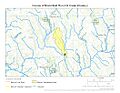
The land area that Bloomfield Run collects water from is called its watershed. This watershed covers about 25.85 square miles (67 square kilometers). Imagine all the rain and snow that falls on this area; it all eventually flows into Bloomfield Run. About half of this land (51%) is covered by forests. The area gets a good amount of rain each year, around 46.1 inches (117 centimeters).
Images for kids
-
The path Bloomfield Run takes.
-

The area of land that drains into Bloomfield Run.
.jpg)
.jpg)
