
Blumine Island / Oruawairua facts for kids
|
Oruawairua (Māori)
|
|
|---|---|
| Geography | |
| Location | Marlborough Sounds South Island |
| Coordinates | 41°10′29″S 174°14′22″E / 41.1748°S 174.2395°E |
| Area | 3.8 km2 (1.5 sq mi) |
| Highest elevation | 298 m (978 ft) |
| Administration | |
| Demographics | |
| Population | 0 |
Blumine Island, also known as Oruawairua in the Māori language, is a special island in the Marlborough Sounds of New Zealand's South Island. Its Māori name, Oruawairua, means 'meeting place of spirits'.
About Blumine Island
Blumine Island is about 377 hectares (932 acres) in size. It is mostly covered in hills. The island is found about 22 kilometers (14 miles) north of Picton. It is a scenic reserve, which means anyone can visit this beautiful island.
Long ago, a visit by Captain James Cook accidentally brought new animals to the island. These animals, called pests, caused problems for the native plants and animals. The Department of Conservation later worked hard to remove these pests. They used helicopters to drop special bait.
In May 2008, Blumine Island was declared free of these pests. After that, efforts began to bring back native animals and plants. This helped the island's natural environment to recover.
Island History
During World War II, soldiers and workers built two gun positions on Blumine Island. These were made to protect a planned American Navy base in the Marlborough Sounds. People were worried about a possible invasion by Japan. The gun sites were no longer needed after the war ended in 1945.
In 2012, new walking tracks were created on the island. These tracks connect the main campsite to the old gun positions. This allows visitors to explore the island's history.
Organizations like Outward Bound and Untouched World Charitable Trust also help care for Blumine Island. They work to keep the island healthy and beautiful.
Kiwi on Blumine Island
On June 29, 2010, something very exciting happened on Blumine Island. Three pairs of a very rare type of kiwi were released there. These kiwi are called rowi (Ōkārito kiwi). This was a big step in helping to protect these special birds.
Images for kids
-
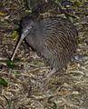
A rowi (Ōkārito kiwi) on Blumine Island / Ōruawairua

See also
 In Spanish: Isla Blumine para niños
