Bohechío facts for kids
Quick facts for kids
Bohechío
|
||
|---|---|---|
|
||
 |
||
| Country | ||
| Province | San Juan | |
| Area | ||
| • Total | 407.82 km2 (157.46 sq mi) | |
| Population
(2012)
|
||
| • Total | 9,652 | |
| • Density | 23.6673/km2 (61.298/sq mi) | |
| • Urban | 4,208 | |
| Distance to – Santo Domingo |
205 km |
|
| Municipal Districts | 2 |
|
| Climate | Aw | |
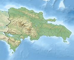
Bohechío is a town in the San Juan province of the Dominican Republic. It is located in the mountains at the foot of the Cordillera Central. The town is about 26.5 kilometers from Azua and 43 kilometers from San Juan Province. It is also 205 kilometers from Santo Domingo. Bohechío covers a land area of about 428.33 square kilometers.
Contents
History of Bohechío
The Taino Chief Bohechío
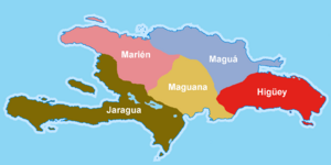
Bohechío was one of the five main chiefs, called Caciques, on the island of Hispaniola. He ruled the Chiefdom of Jaragua. This area is now part of modern-day Haiti.
Bohechío was known for helping his people grow and improve. He helped develop new ways to water crops. He also worked to expand their culture and traditions.
In 1496, Bohechío's brother-in-law, Caonabo, attacked a Spanish fort. Caonabo was killed in this battle. Bohechío then prepared for war. When Bartolome Colon arrived in Jaragua, he found many warriors ready to fight.
Bartolome Colon made the people believe he came in peace. He wanted to honor the chief. Bartolome and his soldiers arrived at Jaragua's main village. Bohechío held a celebration for Colon with songs and dances. After the celebration, Bohechío offered his home to Colon. Peace lasted for several years until the chief's death. His sister, Anacaona, then became the queen of Jaragua.
How Bohechío Became a Municipality
The town of Bohechío began to be settled between 1860 and 1881. This was during the Luis Felipe Vidal revolution. At that time, people in rural areas often moved around. They had no fixed homes because of raids and looting. This forced them to move to safer, more mountainous places.
Some of the first families to settle here were the Piña, Galván, de León, Brioso, Recio, Luciano, Durán, Beltre, and Adames families.
Before it became a municipality, the first settlers named a mountain "Cocobuí." They later called the main town "Buí." On July 24, 1942, the name was changed to "Bohechío." This was done to honor the Taino chief.
In 1966, the President of the Dominican Republic, Joaquín Balaguer, made Bohechío a Municipal District. In 1974, it was officially declared a municipality. It is part of the San Juan province.
Geography of Bohechío
Bohechío is close to several other towns. These include Padre Las Casas (6.4 kilometers away), Las Yayas de Viajama (20 kilometers away), and Guayabal (15.2 kilometers away). These towns are near where the Rio Blanco and Rio Yaque del Sur rivers meet.
The Rio Yaque del Sur is a very important river in the southern Dominican Republic. It starts high in the Cordillera Central mountains, at 2,707 meters. The river flows 183 kilometers downstream. It ends in a river delta in Bahía de Neiba. The water in the river is quite shallow. Only small rafts can travel on it. The land around the river is great for farming. Farmers grow crops like sugarcane, rice, beans, peanuts, bananas, and plantains here.
See also
 In Spanish: Bohechío (municipio) para niños
 | Janet Taylor Pickett |
 | Synthia Saint James |
 | Howardena Pindell |
 | Faith Ringgold |


