Boiling Springs, South Carolina facts for kids
Quick facts for kids
Boiling Springs, South Carolina
|
|
|---|---|

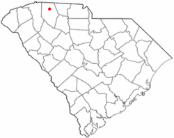
Location of Boiling Springs, South Carolina
|
|
| Country | United States |
| State | South Carolina |
| County | Spartanburg |
| Area | |
| • Total | 6.84 sq mi (17.71 km2) |
| • Land | 6.84 sq mi (17.71 km2) |
| • Water | 0.00 sq mi (0.00 km2) |
| Elevation | 919 ft (280 m) |
| Population
(2020)
|
|
| • Total | 10,405 |
| • Density | 1,521.87/sq mi (587.62/km2) |
| Time zone | UTC−5 (Eastern (EST)) |
| • Summer (DST) | UTC−4 (EDT) |
| ZIP code |
29316
|
| Area code(s) | 864 |
| FIPS code | 45-07345 |
| GNIS feature ID | 1220877 |
| Weather chart for Boiling Springs, South Carolina | |||||||||||||||||||||||||||||||||||||||||||||||
|---|---|---|---|---|---|---|---|---|---|---|---|---|---|---|---|---|---|---|---|---|---|---|---|---|---|---|---|---|---|---|---|---|---|---|---|---|---|---|---|---|---|---|---|---|---|---|---|
| J | F | M | A | M | J | J | A | S | O | N | D | ||||||||||||||||||||||||||||||||||||
|
3.6
53
26
|
2.8
56
28
|
4.1
64
36
|
3.9
73
45
|
3.6
80
54
|
5
88
63
|
5.2
90
66
|
4.3
89
66
|
4.8
83
59
|
3.2
74
45
|
3.7
65
34
|
4.5
55
30
|
||||||||||||||||||||||||||||||||||||
| temperatures in °F precipitation totals in inches source: [1] |
|||||||||||||||||||||||||||||||||||||||||||||||
|
Metric conversion
|
|||||||||||||||||||||||||||||||||||||||||||||||
Boiling Springs is a community in Spartanburg County, South Carolina, United States. It is called a census-designated place (CDP). This means it's a special area that the government tracks for population data. In 2020, about 10,405 people lived there.
Contents
What's in the Name?
Boiling Springs got its name from a unique natural spring. This spring used to look like it was boiling. Sometimes, water would even shoot up to 6 feet into the air!
Over many years, the spring changed. By the 1930s, it was just a small, gently bubbling stream. Today, the water is still and calm.
You can find the spring at the corner of McMillian Boulevard and Highway 9. It's near where a shopping center was built. After the land was developed, the spring stopped "boiling." Now, there's a small park around it with benches and flags.
Where is Boiling Springs?
Boiling Springs is located in South Carolina. Its exact spot is 35°2′35″N 81°58′31″W / 35.04306°N 81.97528°W.
The United States Census Bureau says that Boiling Springs covers about 6.8 square miles (17.7 square kilometers). All of this area is land.
Who Lives in Boiling Springs?
Boiling Springs has grown quite a bit over the years.
| Historical population | |||
|---|---|---|---|
| Census | Pop. | %± | |
| 2000 | 4,544 | — | |
| 2010 | 8,219 | 80.9% | |
| 2020 | 10,405 | 26.6% | |
| U.S. Decennial Census | |||
People in 2020
In 2020, there were 10,405 people living in Boiling Springs. There were also 3,529 households and 2,457 families.
Here's a look at the different groups of people living there:
| Race | Num. | Perc. |
|---|---|---|
| White (non-Hispanic) | 7,217 | 69.36% |
| Black or African American (non-Hispanic) | 1,487 | 14.29% |
| Native American | 23 | 0.22% |
| Asian | 504 | 4.84% |
| Pacific Islander | 1 | 0.01% |
| Other/Mixed | 457 | 4.39% |
| Hispanic or Latino | 716 | 6.88% |
Schools and Learning
Students in Boiling Springs go to schools in Spartanburg County School District 2. This school district is known for its great education.
In the 2013-2014 school year, Spartanburg District 2 was named the best school district in South Carolina! Many teachers in the district have advanced degrees. Also, 19% of them are National Board certified. This puts the district among the top 1% of school districts in the whole country.
Boiling Springs also has a lending library. It is a part of the Spartanburg County Public Library system.
Sherman College of Chiropractic is a college located nearby. Even though it has a Boiling Springs mailing address, it is just outside the main community area.
Famous People from Boiling Springs
Some well-known people have connections to Boiling Springs:
- Brooks Foster, a player in the NFL (National Football League)
- William McGirt, a professional golfer
- Dylan Thompson, an NFL player and coach
- NaJee Thompson, an NFL player
See also
 In Spanish: Boiling Springs (Carolina del Sur) para niños
 | Sharif Bey |
 | Hale Woodruff |
 | Richmond Barthé |
 | Purvis Young |

