
Borders Abbeys Way facts for kids
Quick facts for kids Borders Abbeys Way |
|
|---|---|

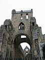
Jedburgh Abbey
|
|
| Length | 109 km (68 mi) |
| Location | Borders, Scotland |
| Established | 2006 |
| Designation | Scotland's Great Trails |
| Trailheads | Circular |
| Use | Hiking |
| Elevation gain/loss | 1,300 metres (4,300 ft) gain |
| Highest point | 339 metres (1,113 ft) |
| Season | All year |
| Sights | Historic ruined abbeys, rivers, wildlife, countryside |
| Website | http://www.bordersabbeysway.com/ |

The Borders Abbeys Way is a fantastic long-distance walking path in the Scottish Borders area of Scotland. It's a circular route, meaning it loops back to where you started, and it's about 109 kilometers (68 miles) long. The main idea behind this path is to connect four amazing ruined abbeys in the Borders region. These abbeys were once homes for monks between the 12th and 16th centuries.
As you walk the trail, you'll discover Kelso Abbey, Jedburgh Abbey, Melrose Abbey, and Dryburgh Abbey. The route also takes you through towns like Hawick and Selkirk. You'll even pass close to Abbotsford House, which was the home of the famous writer Sir Walter Scott. Along the way, you'll see several rivers, including the Jed Water, River Teviot, River Tweed, Ale Water, and Rule Water.
History of the Trail
The Borders Abbeys Way first opened in 2006. It is looked after by the Scottish Borders Council. This path is now officially one of Scotland's Great Trails. These are special routes known for their beauty and importance.
The Borders Abbeys Way also connects with four other Great Trails: the Cross Borders Drove Road, the Romans and Reivers Route, St Cuthbert's Way, and the Southern Upland Way. Every year, about 15,000 people enjoy walking parts of this path. More than 2,000 people even complete the entire circular route!
Walking the Borders Abbeys Way
Most people like to walk the Borders Abbeys Way in sections, usually taking one day for each part. This makes it easier to enjoy the scenery and explore the towns along the way. Here are the main sections and their approximate distances:
- Kelso to Jedburgh: This section is about 19 kilometers (12 miles) long.
- Jedburgh to Hawick: This part covers around 20 kilometers (12.5 miles).
- Hawick to Selkirk: Another section of about 20 kilometers (12.5 miles).
- Selkirk to Melrose: This is a shorter section, about 16 kilometers (10 miles).
- Melrose to Kelso: The final stretch is the longest, at about 28 kilometers (17.5 miles).
If you walk the whole trail, you'll cover a total of about 103 kilometers (64 miles). The highest point on the entire walk is about 339 meters (1,113 feet) high.
Images for kids
-
Jedburgh Abbey
