Bordj Bou Arréridj Province facts for kids
Quick facts for kids
Bordj Bou Arréridj Province
ولاية برج بوعريريج
|
|
|---|---|

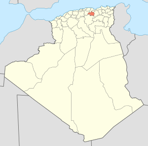
Map of Algeria highlighting Bordj Bou Arréridj
|
|
| Country | |
| Capital | Bordj Bou Arréridj |
| Area | |
| • Total | 4,115 km2 (1,589 sq mi) |
| Population
(2008)
|
|
| • Total | 634,396 |
| • Density | 154.167/km2 (399.29/sq mi) |
| Time zone | UTC+01 (CET) |
| Area Code | +213 (0) 35 |
| ISO 3166 code | DZ-34 |
| Districts | 10 |
| Municipalities | 34 |
Bordj Bou Arréridj Province is a special area in the eastern part of Algeria. It's like a big region or state. This province is about 200 kilometers (about 124 miles) away from Algiers, which is the capital city of Algeria. The main city and capital of this province is also called Bordj Bou Arréridj.
How the Province is Organized
Bordj Bou Arréridj Province is divided into smaller parts to help manage everything. Think of it like a country being divided into states, and states being divided into counties.
Districts and Municipalities
This province has 10 main areas called districts. Within these districts, there are 34 even smaller areas called municipalities or communes. Each municipality is like a town or a group of villages that work together.
Here are the 10 districts:
- Aïn Taghrout
- Bir Kasd Ali
- Bordj Bou Arréridj (This district is also the main city of the province!)
- Bordj Ghedir
- Bordj Zemmoura
- Djaâfra
- El Hamadia
- Mansourah
- Medjana
- Ras El Oued
See also
 In Spanish: Provincia de Bordj Bou Arréridj para niños
 | John T. Biggers |
 | Thomas Blackshear |
 | Mark Bradford |
 | Beverly Buchanan |

