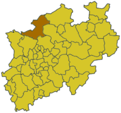
Borken is a special kind of area in Germany called a Landkreis, which means a rural district or county. It's located in the northwestern part of North Rhine-Westphalia, a state in Germany. Think of it like a county in other countries, where several towns and villages come together.
History of Borken District
The Borken district was created in 1975. Before that, the area was made up of several smaller districts and cities. To form the new Borken district, parts of the old Ahaus district, the city of Bocholt, and small sections from the districts of Rees, Recklinghausen, and Coesfeld were all joined together. This brought many communities under one new administration.
What Does the Borken Coat of Arms Mean?
 |
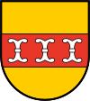
The colors used in the Borken district's coat of arms are the same as those of Münster. Münster was an important city that owned this region for a very long time. The three white anchors you see in the middle come from the coat of arms of a historical area called the Herrschaft Anholt. These three anchors are shown to represent the three main parts that formed the new district: the old Borken district, the Ahaus district, and the city of Bocholt. |
Towns and Municipalities in Borken
The Borken district is home to many different towns and smaller communities called municipalities. Each of these places has its own unique character and history. Here's a list of them:
| Towns |
Municipalities |
- Ahaus
- Bocholt
- Borken
- Gescher
- Gronau
- Isselburg
- Rhede
- Stadtlohn
- Vreden
|
- Heek
- Heiden
- Legden
- Raesfeld
- Reken
- Schöppingen
- Südlohn
- Velen
|


