Bourneville, Ohio facts for kids
Quick facts for kids
Bourneville, Ohio
|
|
|---|---|

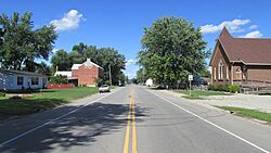
Looking east on Main Street (US Highway 50) in Bourneville
|
|

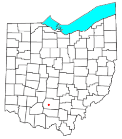
Location of Bourneville, Ohio
|
|
| Country | United States |
| State | Ohio |
| County | Ross |
| Township | Twin |
| Elevation | 696 ft (212 m) |
| Population | |
| • Total | 241 |
| Time zone | UTC-5 (Eastern (EST)) |
| • Summer (DST) | UTC-4 (EDT) |
| ZIP |
45617
|
| GNIS feature ID | 2628867 |
Bourneville is a small community in Ross County, Ohio, United States. It is called a census-designated place (CDP). This means it's an area that looks like a town but isn't officially a city or village.
Bourneville is located in central Twin Township. It sits along U.S. Route 50, a major road. In 2020, about 241 people lived there. The community has its own post office with the ZIP code 45617.
Contents
History of Bourneville
When was Bourneville first settled? The first people to settle permanently in Bourneville arrived in the 1790s. This was a long time ago, even before Ohio became a state!
Who founded Bourneville? The town was officially planned and laid out in 1832. This process is called "platting." Colonel Bourne was the person who did this, and the town was named after him. The post office in Bourneville has been open since 1832.
Ancient Stone Works Near Bourneville
What ancient structures are near Bourneville? In 1847, people found an ancient stone structure near Bourneville. This structure was built by Native Americans a very long time ago.
Two important researchers, Ephraim George Squier and Edwin Hamilton Davis, studied this stone work. They included it in their famous book, Ancient Monuments of the Mississippi Valley, which came out in 1848. Their book helped people learn about the amazing ancient cultures of the Mississippi Valley.
Famous People from Bourneville
Who is a notable person from Bourneville?
- Philip Caldwell was a well-known businessman. He was born in Bourneville.
See also
 In Spanish: Bourneville (Ohio) para niños
 | Calvin Brent |
 | Walter T. Bailey |
 | Martha Cassell Thompson |
 | Alberta Jeannette Cassell |


