Bowmansville, Pennsylvania facts for kids
Quick facts for kids
Bowmansville, Pennsylvania
|
|
|---|---|

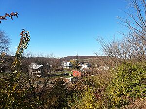
View of Bowmansville from the Bowmansville Service Plaza
|
|
| Country | United States |
| State | Pennsylvania |
| County | Lancaster |
| Township | Brecknock |
| Founded | 1820 |
| Area | |
| • Total | 2.15 sq mi (5.56 km2) |
| • Land | 2.13 sq mi (5.53 km2) |
| • Water | 0.01 sq mi (0.03 km2) |
| Elevation | 434 ft (132 m) |
| Population
(2020)
|
|
| • Total | 2,989 |
| • Density | 1,400.66/sq mi (540.80/km2) |
| Time zone | UTC-5 (Eastern (EST)) |
| • Summer (DST) | UTC-4 (EDT) |
| ZIP code |
17507
|
| Area code(s) | 717 |
| FIPS code | 42-07896 |
| GNIS feature ID | 1170075 |
Bowmansville is a small community in Lancaster County, Pennsylvania, in the United States. It is a "census-designated place" (CDP). This means it's an area that the government counts as a separate place for population studies.
Bowmansville is located within Brecknock Township. A well-known spot here is the Bowmansville Service Plaza, which is part of the Pennsylvania Turnpike. In 2020, about 2,989 people lived in Bowmansville.
Contents
History of Bowmansville
How Bowmansville Got Its Name
Bowmansville was named after an early settler. His name was Samuel Bowman.
Historic Buildings in Bowmansville
Two important buildings in Bowmansville are listed on the National Register of Historic Places. This is a special list of places that are important to American history.
- The Bowmansville Roller Mill
- The John B. Good House
Geography of Bowmansville
Where is Bowmansville Located?
Bowmansville is in the northeastern part of Lancaster County. It is also near the middle of Brecknock Township.
The Pennsylvania Turnpike (also known as Interstate 76) goes through Bowmansville. However, you cannot get on or off the turnpike directly from Bowmansville. The closest exit is about 4 miles (6.4 km) to the west, near Swartzville. This exit leads to Reading. Another exit is about 10 miles (16 km) to the east, near Morgantown.
Roads and Rivers
Pennsylvania Route 625 (Reading Road) runs right through the center of Bowmansville. If you go north on this road, you will reach Reading, which is about 12 miles (19 km) away. If you go south, you will get to East Earl, about 7 miles (11 km) away. Lancaster, the main city of the county, is about 21 miles (34 km) to the southwest.
Bowmansville covers an area of about 2.15 square miles (5.56 square kilometers). Most of this area is land. A small part, about 0.01 square miles (0.03 square kilometers), is water.
The community gets its water from Muddy Creek. This creek flows west and joins the Conestoga River. The Conestoga River then flows into the Susquehanna River.
Population Information
| Historical population | |||
|---|---|---|---|
| Census | Pop. | %± | |
| 2020 | 2,989 | — | |
| U.S. Decennial Census | |||
See also
 In Spanish: Bowmansville para niños
 | John T. Biggers |
 | Thomas Blackshear |
 | Mark Bradford |
 | Beverly Buchanan |


