Braceville, Illinois facts for kids
Quick facts for kids
Braceville
|
|
|---|---|

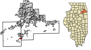
Location of Braceville in Grundy & Will Counties, Illinois.
|
|

Location of Illinois in the United States
|
|
| Country | United States |
| State | Illinois |
| County | Grundy, Will |
| Area | |
| • Total | 3.34 sq mi (8.65 km2) |
| • Land | 3.11 sq mi (8.06 km2) |
| • Water | 0.23 sq mi (0.59 km2) |
| Elevation | 594 ft (181 m) |
| Population
(2020)
|
|
| • Total | 724 |
| • Density | 232.72/sq mi (89.85/km2) |
| Time zone | UTC-6 (CST) |
| • Summer (DST) | UTC-5 (CDT) |
| Area code(s) | 815 & 779 |
| FIPS code | 17-07640 |
| GNIS feature ID | 2398160 |
| Wikimedia Commons | Braceville, Illinois |
Braceville is a small village located in Illinois, a state in the United States. Most of Braceville is in Grundy County, but a small part is also in Will County. In 2020, about 724 people lived there.
Contents
History of Braceville
Braceville was first started in 1834 by Reverend L. S. Robbins. He called the new settlement "Sulphur Springs." After Reverend Robbins passed away, the town chose its first leader, B. R. Dowd, in 1848. Mr. Dowd decided to change the town's name to Braceville. He named it after his hometown, Braceville Township, Ohio.
For a while, people in Braceville were very interested in mining because coal was found nearby. However, no coal mines were ever actually opened in the village. Over time, the town started to focus on other types of work and businesses. The number of people living in Braceville has changed a lot over the years, but it is now slowly growing.
Geography of Braceville
Braceville covers an area of about 3.34 square miles (8.65 square kilometers). Most of this area, about 3.11 square miles (8.06 square kilometers), is land. The rest, about 0.23 square miles (0.59 square kilometers), is water. This means that about 93% of Braceville is land, and nearly 7% is water.
People of Braceville
| Historical population | |||
|---|---|---|---|
| Census | Pop. | %± | |
| 1880 | 278 | — | |
| 1890 | 2,150 | 673.4% | |
| 1900 | 1,669 | −22.4% | |
| 1910 | 971 | −41.8% | |
| 1920 | 303 | −68.8% | |
| 1930 | 219 | −27.7% | |
| 1940 | 321 | 46.6% | |
| 1950 | 384 | 19.6% | |
| 1960 | 558 | 45.3% | |
| 1970 | 668 | 19.7% | |
| 1980 | 721 | 7.9% | |
| 1990 | 587 | −18.6% | |
| 2000 | 792 | 34.9% | |
| 2010 | 793 | 0.1% | |
| 2020 | 724 | −8.7% | |
| U.S. Decennial Census | |||
In 2020, there were 724 people living in Braceville. These people lived in 288 different homes, and 202 of those were families. The village has about 217 people living in each square mile.
Most people in Braceville are White, making up about 91.7% of the population. A small number of people are from African American, Native American, or Asian backgrounds. About 4.8% of the people are Hispanic or Latino.
About one-third of the homes in Braceville had children under 18 living there. Most homes, about 60%, were married couples. Some homes had a female head of household without a husband. About 23% of homes were single individuals.
The average age of people in Braceville was about 34.7 years old. Many young people live here, with about 37% of the population being under 18.
The average income for a family in Braceville was around $86,786 per year. The average income for each person in the village was about $29,773. About 9.8% of all people in Braceville lived below the poverty line.
The Old Bridge
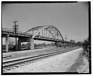
For many years, a special kind of bridge called a "bowstring arch bridge" helped cars cross a railroad track and a creek south of Braceville. This bridge was part of a famous road called Route 66, and later Route 129.
This bridge was unique because it had a curved top structure, like a bow, that supported the flat road below. Another road, Route 53, ran next to it but didn't need a bridge in that spot.
In 1994, the old arch bridge was closed because it was no longer safe. It was completely taken down in the year 2000.
Famous Folks
- Al Braithwood was a baseball pitcher who played for the Pittsburgh Rebels team. He was from Braceville.
See also
 In Spanish: Braceville (Illinois) para niños
 | William M. Jackson |
 | Juan E. Gilbert |
 | Neil deGrasse Tyson |


