Bradogue River facts for kids
Quick facts for kids Bradogue River |
|
|---|---|

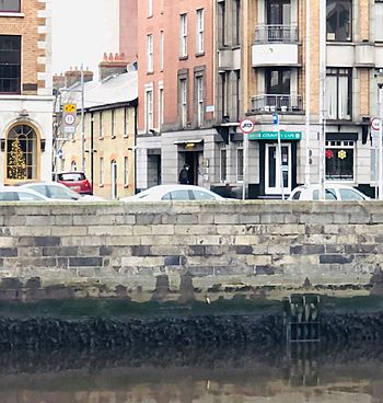
Main outfall of the Bradogue River from culvert to River Liffey, Ormond Quay
|
|
| Native name | Bradóg |
| Other name(s) | Bradoge, Bradok, Glascoynock, the Pole Water, St Michan's Streams, Le Rughdich |
| Physical characteristics | |
| Main source | Cabra |
| River mouth | River Liffey Ormond Quay 53°20′45″N 6°16′11″W / 53.3458°N 6.2698°W |
| Basin features | |
| River system | River Liffey |
The Bradogue River is a small river in Dublin, Ireland. It starts in an area called Cabra and flows into the famous River Liffey. You can see its main exit point at Ormond Quay. Today, the entire river flows underground in pipes, which is called being "culverted."
Contents
What's in a Name? The Bradogue River's History
The Bradogue River has had many names over time. Since the 1700s, people have mostly called it Bradoge, Bradok, or Bradogue. But before that, it was known by other names like Glascoynock, St Michan's Streams, and even Le Rughdich.
Meaning of "Bradogue"
The name Bradogue comes from the Irish word Bradóg. This word means "young salmon." It's a cool name for a river, even if you can't see salmon there today!
Other Old Names Explained
- Glascoynock: This name came from "Glasmacanóg." It means "the stream of Canoc." Canoc was an old Welsh-Irish saint. This was the most common name for the river from the time of the Vikings until the 1700s.
- St Michan's Streams: This name came about when the Norse people living in Dublin had to move to a new area called Oxmanstown. This happened after the Anglo-Normans took control of the main walled city.
- Pole Water: This name probably came from "Pill Water." A "pill" was a muddy area where a small river would split into many smaller streams before joining a bigger river like the Liffey.
Where Does the Bradogue River Flow?
Today, you can't see the Bradogue River because it flows completely underground. It's hidden away in pipes and is part of Dublin's city drainage system.
The River's Journey Underground
The Bradogue River starts in western Cabra, near a park called Pope John Paul II Park. From there, it flows east.
A lot of the river's early water is sent north to another river, the River Tolka, through a special sewer pipe. But some of the water continues on the Bradogue's original path, going under the railway tracks into eastern Cabra.
The river then passes under the North Circular Road and goes through the Grangegorman campus. It then flows under the old Broadstone Railway Terminal, which is now a bus depot. At some point, a side branch was built here to take some of the water more directly to the Liffey.
Through Dublin City
The main historical path of the Bradogue River goes under where the Royal Canal harbour used to be. It also passes near Constitution Hill and Broadstone Road. The name "Broadstone" might even come from "Bradoge-Steyn," which means a simple stone bridge over the river in old Norse.
The river then flows along the edge of the Kings Inns grounds. It goes near Dominick Street, Henrietta Lane, and Bolton Street. Then it makes a sharp turn towards the southwest. It continues under streets like Kings Street, Green Street, Halston Street, and Mary's Lane. It even passes under the area where the old Fruit and Vegetable Market used to be, and then under Ormond Square.
Most of the river's water joins the general sewer system at this point. However, its path still reaches the River Liffey at Ormond Quay.
The Secondary Path
The secondary path of the river, which splits off at Broadstone, flows towards North Brunswick Street. It goes under Smithfield, past an old distillery site, and then under Arran Street North. This path also reaches the River Liffey, a bit downstream from Mellowes Bridge.
 | Tommie Smith |
 | Simone Manuel |
 | Shani Davis |
 | Simone Biles |
 | Alice Coachman |

