Braid Burn facts for kids
Quick facts for kids Braid Burn |
|
|---|---|

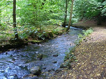
The Braid Burn in the Hermitage of Braid
|
|
| Physical characteristics | |
| Main source | Pentland Hills |
| River mouth | Portobello |
| Length | 14 km (8.7 mi) |
| Basin features | |
| Basin size | 30.5 km2 (11.8 sq mi) |
The Braid Burn is a stream, like a small river, that flows for about 14 kilometers (9 miles). It runs through the southern and eastern parts of Edinburgh, a big city in Scotland.
Contents
Where the Braid Burn Flows
The Braid Burn starts near Bonaly in the Pentland Hills. These hills are to the south-west of Edinburgh. The burn begins when two smaller streams, the Bonaly Burn and Howden Burn, join together.
Journey Through Edinburgh
From its start, the Braid Burn generally flows towards the north-east. It passes by the Braid Hills and goes through several green spaces. These include the Braid Valley Park, the beautiful Hermitage of Braid, and Blackford Glen. It also flows past Cameron Toll and Inch Park.
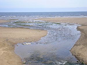
When the burn reaches Peffermill, another stream called the Jordan Burn joins it. As it gets to Duddingston, its name changes to the Figgate Burn. Finally, it flows into the Firth of Forth at Portobello, which is on the coast.
Water and Land Around the Burn
The area of land that drains water into the Braid Burn and its smaller streams is about 30.5 square kilometers (11.8 square miles). The burn can rise very quickly after heavy rain. This means it can become much larger and flow very fast. Most of the area that feeds the burn is in the city.
The burn flows through a deep valley in some places. This valley was carved out by melting ice from glaciers long ago. This natural gorge stopped houses from being built right next to the burn. Because of this, the Braid Burn flows through several miles of parkland, which is great for nature and people.
Animals Living in the Burn
The Braid Burn is home to some interesting wildlife. You can find small trout and fish called bullhead swimming in its waters. Sometimes, lucky visitors might even spot otters playing or hunting along the burn's banks.
Stopping Floods Along the Burn
The Braid Burn has a history of causing floods. There have been many times when the burn overflowed its banks. This happened on dates like January 3, 1982, and October 2002, causing problems for nearby homes and businesses.
How Floods Are Prevented Now
After serious floods in 2000, the City of Edinburgh Council decided to build a special flood prevention system. This system was built along much of the burn's path. Walls and raised banks were constructed to hold back water. New pipes and bridges were also put in place.
Changes were made to reservoirs in the Pentland Hills that feed the burn. Parks and golf courses were also changed. They can now hold extra water if there's a flood. This helps to protect about 900 properties from flooding. The whole project was finished in 2010. It was designed to handle very large floods, like ones that might happen only once every 200 years.
 | Kyle Baker |
 | Joseph Yoakum |
 | Laura Wheeler Waring |
 | Henry Ossawa Tanner |


