Braswell, Georgia facts for kids
Quick facts for kids
Braswell, Georgia
|
||
|---|---|---|

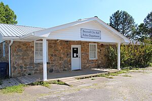
City hall
|
||
|
||

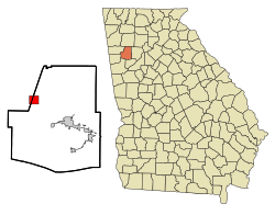
Location in Paulding County and the state of Georgia
|
||
| Country | United States | |
| State | Georgia | |
| Counties | Polk, Paulding | |
| Area | ||
| • Total | 3.18 sq mi (8.23 km2) | |
| • Land | 3.16 sq mi (8.20 km2) | |
| • Water | 0.01 sq mi (0.03 km2) | |
| Elevation | 1,161 ft (354 m) | |
| Population
(2020)
|
||
| • Total | 355 | |
| • Density | 112.20/sq mi (43.32/km2) | |
| Time zone | UTC-5 (Eastern (EST)) | |
| • Summer (DST) | UTC-4 (EDT) | |
| Area code(s) | 770/678/470 | |
| FIPS code | 13-10104 | |
| GNIS feature ID | 0331229 | |
Braswell is a small city in the state of Georgia, USA. It is located across two counties: Polk and Paulding. In 2020, about 355 people lived there.
Contents
Where is Braswell?
Braswell is located in the western part of Georgia. Its exact coordinates are 33°59′2″N 84°57′34″W / 33.98389°N 84.95944°W.
How Big is Braswell?
The city covers a total area of about 3.1 square miles (8.2 square kilometers). Most of this area is land, with a very small part being water.
A Look at Braswell's History
Braswell started as a town in 1882. This was when a railway line, the East Tennessee Virginia & Georgia Railroad, reached this spot. This railway later became part of the Southern Railway in 1894.
Who Was Braswell Named After?
The city got its name from Henry S. Braswell (1832–1902). He was an important person in Paulding County. Henry Braswell owned a lot of land in the area. He worked with William McCracken in the land and timber business. They supplied wood for railway ties and bridge timbers to the Southern Railway and Seaboard Air Line Railroad.
Railroad Tunnels Near Braswell
Braswell was home to the only tunnel on the main railway line from Chattanooga to Atlanta. This line is now used by the Norfolk Southern Railway. The original tunnel was replaced in 1979. Workers cut through Braswell mountain a bit to the east to create a new path.
Another tunnel nearby is the Brushy Mountain tunnel. It was part of the old Seaboard Air Line Railroad route. Today, this tunnel is used by people who enjoy biking and jogging. It is part of a long trail called the Georgia/Alabama Silver Comet Trail. The part of the trail in Georgia is called the Silver Comet Trail. The part in Alabama is known as the Chief Ladiga Trail. The Silver Comet Trail was named after a famous passenger train, the Silver Comet, that once traveled this route.
People of Braswell
| Historical population | |||
|---|---|---|---|
| Census | Pop. | %± | |
| 1900 | 100 | — | |
| 1910 | 95 | −5.0% | |
| 1920 | 58 | −38.9% | |
| 1930 | 76 | 31.0% | |
| 1940 | 56 | −26.3% | |
| 1950 | 25 | −55.4% | |
| 1960 | 14 | −44.0% | |
| 1970 | 30 | 114.3% | |
| 1980 | 282 | 840.0% | |
| 1990 | 247 | −12.4% | |
| 2000 | 80 | −67.6% | |
| 2010 | 379 | 373.8% | |
| 2020 | 355 | −6.3% | |
| U.S. Decennial Census | |||
Population in 2020
In 2020, the 2020 United States census counted 355 people living in Braswell. There were 131 households and 89 families in the city.
| Group | Number | Percentage |
|---|---|---|
| White (not Hispanic) | 294 | 82.82% |
| Black or African American (not Hispanic) | 32 | 9.01% |
| Native American | 1 | 0.28% |
| Asian | 1 | 0.28% |
| Other/Mixed | 10 | 2.82% |
| Hispanic or Latino | 17 | 4.79% |
See also
 In Spanish: Braswell (Georgia) para niños


