Bray Island facts for kids

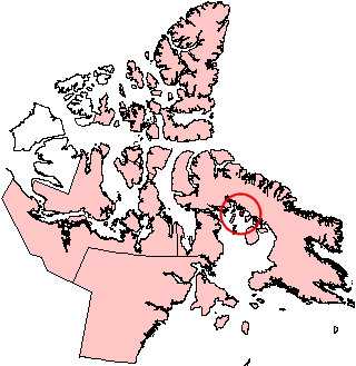
Bray Island, Nunavut.
|
|
| Geography | |
|---|---|
| Location | Foxe Basin |
| Coordinates | 69°16′N 77°00′W / 69.267°N 77.000°W |
| Archipelago | Canadian Arctic Archipelago |
| Area | 689 km2 (266 sq mi) |
| Administration | |
| Territory | Nunavut |
| Region | Qikiqtaaluk |
| Demographics | |
| Population | Uninhabited |
Bray Island is a cool island located in the Canadian Arctic Archipelago, which is a huge group of islands in northern Canada. It's part of Nunavut, Canada's largest and northernmost territory. You can find Bray Island along the southern coast of a much bigger island called Baffin Island.
This island sits in a large body of water known as Foxe Basin. It's located at about 69°16' North and 77°00' West. Bray Island covers an area of about 689 square kilometers (that's about 266 square miles). To give you an idea, that's roughly the size of a large city like Toronto, Canada, or a small country like Singapore!
Contents
What Makes Bray Island Special?
Bray Island might be uninhabited now, but it played an important role in the past. It was once home to a special military site called FOX-A. This site was part of a big defense system.
The Distant Early Warning Line
FOX-A was originally a station for the Distant Early Warning Line, often called the DEW Line. This was a chain of radar stations built across the northern parts of Canada, Alaska, and Greenland during the 1950s. Its main purpose was to detect incoming aircraft or missiles from the Soviet Union during the Cold War.
Why Was the DEW Line Built?
The DEW Line was built to give North America an early warning if there was an air attack. Imagine a tripwire across the Arctic! If anything flew over, the radar stations would pick it up. This would give leaders time to react and protect their countries. Bray Island's location made it a perfect spot for one of these crucial stations.
From DEW Line to North Warning System
Over time, technology changed. The DEW Line eventually became part of the North Warning System. This newer system uses more advanced radar technology. It still helps protect North American airspace today. Even though Bray Island's station, FOX-A, is no longer active, its history is a reminder of its past importance in defense.
Images for kids
See also
 In Spanish: Isla Bray para niños
 | John T. Biggers |
 | Thomas Blackshear |
 | Mark Bradford |
 | Beverly Buchanan |


