Breckinridge, Oklahoma facts for kids
Quick facts for kids
Breckinridge, Oklahoma
|
|
|---|---|

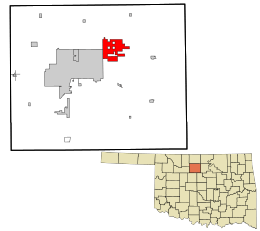
Location in Garfield County and the state of Oklahoma.
|
|
| Country | United States |
| State | Oklahoma |
| County | Garfield |
| Area | |
| • Total | 15.29 sq mi (39.59 km2) |
| • Land | 15.23 sq mi (39.45 km2) |
| • Water | 0.06 sq mi (0.15 km2) |
| Elevation | 1,198 ft (365 m) |
| Population
(2020)
|
|
| • Total | 199 |
| • Density | 13.07/sq mi (5.04/km2) |
| Time zone | UTC-6 (Central (CST)) |
| • Summer (DST) | UTC-5 (CDT) |
| FIPS code | 40-08600 |
| GNIS feature ID | 1090465 |
Breckinridge, sometimes spelled Breckenridge, is a small town in Garfield County, Oklahoma, United States. In 2020, about 199 people lived there. It's a quiet place with a unique history.
Contents
History of Breckinridge
How Breckinridge Started
The town of Breckinridge began because of railroads. In 1899, the Enid and Tonkawa Railway built tracks through this area. Later, another railroad, the Blackwell, Enid and Southwestern Railroad, also built tracks here between 1900 and 1901. These two railroads crossed paths right where Breckinridge is now.
Naming the Town
In March 1901, a company called the Frisco Town Company planned out the town. They named it after Breckinridge Jones. He was an important person who invested a lot of money in railroads. The town's post office first used the spelling "Breckenridge." But just two months later, they changed it to "Breckinridge," which is how it's spelled today.
Population Changes Over Time
Breckinridge has seen its population change quite a bit. In 1960, only 42 people lived there. The post office even closed in November 1963 because there were so few people. However, the town grew again in the 1970s. This happened after a large fertilizer plant was built nearby, bringing more jobs and people to the area.
Geography of Breckinridge
Where is Breckinridge Located?
Breckinridge is located in the state of Oklahoma. It is east of a larger city called Enid. You can find it north of US Route 412 on a road called North 102nd Street.
Land and Water Area
The town covers a total area of about 15.2 square miles (39.59 square kilometers). Most of this area is land, about 15.1 square miles (39.45 square kilometers). A very small part, about 0.1 square miles (0.15 square kilometers), is water.
Population Information
| Historical population | |||
|---|---|---|---|
| Census | Pop. | %± | |
| 1920 | 132 | — | |
| 1930 | 76 | −42.4% | |
| 1940 | 80 | 5.3% | |
| 1950 | 67 | −16.2% | |
| 1960 | 42 | −37.3% | |
| 1970 | 261 | 521.4% | |
| 1980 | 261 | 0.0% | |
| 1990 | 251 | −3.8% | |
| 2000 | 239 | −4.8% | |
| 2010 | 245 | 2.5% | |
| 2020 | 199 | −18.8% | |
How Many People Live Here?
As of the year 2000, there were 239 people living in Breckinridge. These people lived in 94 households, and 73 of these were families. The town had about 15.8 people per square mile.
Who Lives in Breckinridge?
In 2000, most of the people in Breckinridge were White (about 92.89%). There were also people who identified as Native American (2.93%), from other races (1.67%), or from two or more races (2.51%). About 2.09% of the population was Hispanic or Latino.
Households and Families
Out of the 94 households, about 33% had children under 18 living with them. Most households (68.1%) were married couples living together. The average household had about 2.54 people, and the average family had about 2.95 people.
Age Groups
The population in Breckinridge was spread out across different age groups. About 25.9% of the people were under 18 years old. About 12.1% were 65 years old or older. The average age in the town was 40 years.
Education in Breckinridge
Most of the students in Breckinridge attend schools in the Garber Public Schools district. A smaller part of the town, in the northeast, is part of the Kremlin-Hillsdale Schools district.
See also
 In Spanish: Breckenridge (Oklahoma) para niños

