Bremner River facts for kids
Quick facts for kids Bremner River |
|
|---|---|

Bremner River
|
|
|
Location of the mouth of the Bremner River in Alaska
|
|
| Country | United States |
| State | Alaska |
| Census Area | Valdez–Cordova |
| Physical characteristics | |
| Main source | confluence of its north and middle forks Chugach Mountains, Wrangell–St. Elias National Park and Preserve 651 ft (198 m) 60°58′41″N 143°53′36″W / 60.97806°N 143.89333°W |
| River mouth | Copper River 45 miles (72 km) north of Katalla 174 ft (53 m) 60°50′42″N 144°31′00″W / 60.84500°N 144.51667°W |
| Length | 40 mi (64 km) |
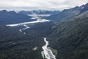
The Bremner River is a river in Alaska, a state in the United States. It flows for about 40 miles (64 km) (64 kilometers). This river is a branch, or tributary, of the larger Copper River. You can find it in the Valdez–Cordova Census Area.
The river got its name in 1885 from Lieutenant H. T. Allen. He named it after John Bremner, who was a prospector. John Bremner was looking for gold along the river. He was also the first non-native person to explore this area.
The Bremner River starts in the Chugach Mountains. It flows generally towards the southwest. Eventually, it joins the Copper River. This meeting point is about 45 miles (72 km) (72 kilometers) north of a place called Katalla. The river has a "North Fork" which begins at the Bremner Glacier. This glacier is about 8 miles (13 km) (13 kilometers) long. The entire river flows through Wrangell–St. Elias National Park and Preserve. This is a very large and wild park.
Boating on the Bremner River
Boating on the Bremner River is an adventure for experienced people. The main part of the river is suitable for those with advanced boating skills. It is not for beginners. The river's difficulty is rated using the International Scale of River Difficulty.
River Difficulty Ratings
The Bremner River is rated from Class II to Class IV.
- Class II means the river has easy rapids. These rapids have clear passages.
- Class IV means the river has very difficult rapids. These rapids are powerful and require precise handling. They can be dangerous.
Challenges for Boaters
The river flows through mountains and thick forests. This makes it hard to get to the river. Hiking in the area can also be tough. There are other things to be aware of:
- The water is cold and moves fast.
- It can be silty, meaning it has a lot of mud or sand.
- The area is very isolated, far from towns or help.
- Some parts have narrow canyons.
- Brown bears live in this region.
- Strong winds can blow near where the river meets the Copper River.
 | Stephanie Wilson |
 | Charles Bolden |
 | Ronald McNair |
 | Frederick D. Gregory |


