
Brewarrina Aboriginal Fish Traps facts for kids
Quick facts for kids Brewarrina Aboriginal Fish Traps |
|
|---|---|

The fish traps in 2023
|
|
| Location | Brewarrina, Brewarrina Shire, New South Wales, Australia |
| Architect | Baime |
| Owner | Brewarrina Local Aboriginal Land Council; Brewarrina Shire Council; Crown Lands LPMA; NSW Office of Water |
| Official name: Brewarrina Aboriginal Fish Traps / Baiame's Ngunnhu; Aboriginal Fishtraps; fisheries; Nonah; Nyemba Fish Traps; Biame; Biaime; Baime; water fishery | |
| Type | state heritage (landscape) |
| Designated | 11 August 2000 |
| Reference no. | 1413 |
| Type | Fish/eel trap |
| Category | Aboriginal |
| Builders | Baime, Booma-ooma-nowi and Ghindi-inda-mui |
| Lua error in Module:Location_map at line 420: attempt to index field 'wikibase' (a nil value). | |
The Brewarrina Aboriginal Fish Traps are amazing ancient fish traps built by Aboriginal people on the Barwon River in Brewarrina, New South Wales, Australia. They are also known as Baiame's Ngunnhu (pronounced By-ah-mee's noon-oo). Right next to the traps, you'll find the Brewarrina Aboriginal Cultural Museum, which opened in 1988. These traps are so important that they were added to the New South Wales State Heritage Register in 2000 and the Australian National Heritage List in 2005. Some experts even think these fish traps might be the oldest human-made structures in the world! Their exact age is still a mystery.
Contents
Discover the Brewarrina Fish Traps
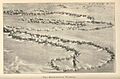
The Brewarrina Aboriginal Fish Traps, or Baiame's Ngunnhu, are a series of stone walls and pools. They look like a giant stone net stretched across the Barwon River. These traps cover about 400 meters of the riverbed. Here, the river flows quickly and is quite shallow.
How the Traps Were Built
The people who built these traps were very clever. They placed rocks tightly together, often sideways, to make the walls strong. They also put large stones on top, like caps, to add more stability. The traps are shaped like teardrops, which helped them stand strong against the river's flow. The curved parts acted like arches, pushing back against the water. This design shows a deep understanding of how rivers work and how to build with stones.
The River and Its Surroundings
The fish traps are in a dry, hot area called the Darling Riverine Plains Bioregion. The Barwon River itself starts far away in Queensland. It changes names as it flows, eventually becoming the Darling River. The river's health has changed a lot since European settlement. Things like farming and dams have affected its flow and water quality.
The rocks where the traps are built are a rare sight in this area. Nearby, there's also a special clay cliff. This clay was an important source of ochre, a natural pigment used by the Ngemba people for art and body decoration.
A Glimpse into History
Traditional Land and People
The traditional custodians of the fish traps are the Ngemba Wayilwan people. Many other Aboriginal groups also lived nearby and visited the traps. Before Europeans arrived, it's thought that about 3,000 people lived in this region. River communities often stayed along the rivers in summer. In winter, they moved to drier campsites.
Rivers were like highways for travel and trade. Each tribe had its own land, often marked by natural features. You can still find signs of their lives today. These include old campsites, cooking mounds (middens), scarred trees, and ceremonial sites. The areas along the rivers have many archaeological remains. This shows how much people used these places.
Before British settlement, thousands of people gathered at these fish traps. They held large corroborees, which are important ceremonies and meetings. Each group followed strict rules for using the traps.
The Creation Story
The story of how the Ngunnhu was made is very old and important. Many Aboriginal people believe the fish traps were designed by Baiame. He is a great ancestral being respected by many groups in western NSW. The story has been passed down through generations.
The legend says Baiame came to the river during a drought. The Ngemba Wayilwan people were struggling because the river had dried up. To help them, Baiame planned the amazing fish traps. He cast his great net across the river to create the design. His two sons, Booma-ooma-nowi and Ghinda-inda-mui, then built the traps from stones, following their father's net pattern.
Baiame then taught the Ngemba Wayilwan men how to call for rain with dance and song. When the rain came, the river filled, and thousands of fish swam into Baiame's net. The elders then guided the fish into the stone pens. Baiame taught the Ngemba Wayilwan how to use and care for the Ngunnhu. He said that other groups should also share in the traps' use and maintenance. Everyone who used the traps felt very grateful to Baiame.
Two large footprints made by Baiame are said to be at the Ngunnhu. One of these can still be seen today. It is believed that wherever Baiame camped, some of his spirit remains. This makes the Ngunnhu a very spiritual place.
Baiame's story is just one of many creation stories in the Brewarrina area. These stories connect different landscape features over long distances. This means the fish traps are important to Aboriginal people from many different places, not just those living nearby.
How Old Are the Fish Traps?
Some people think these fish traps could be the oldest human-made structure in the world. But their exact age is still unknown.
Because the traps are in a riverbed, they would have changed over time. The river's flow would have moved stones. Aboriginal people also kept adding to or changing the traps over hundreds or thousands of years. This constant work makes it hard to say exactly when they were first built.
Scientists look at how the Barwon River's flow has changed over time. The traps would have worked best when water levels were often low. Studies of other rivers in the area suggest long periods of low flow happened between 15,000 and 9,000 years ago, and again from about 3,000 years ago until now. We don't know if these dates apply to the Barwon River too.
Early European Accounts
The first known European mention of the fish traps was in 1848. W. C. Mayne, a government official, noted: "To form these must have been a work of no trifling labour, and no slight degree of ingenuity and skill must have been exercised in their construction." He was told that even the biggest floods didn't move the stones.
In 1861, William Richard Randell, a riverboat captain, also described the traps. He called them "the Black's fishing-grounds" and noted the "great number of circular walls of stone."
The first detailed studies were done in the early 1900s. Robert Hamilton Mathews, an early Australian anthropologist, visited in 1901. He wrote the first detailed descriptions, learning much from Aboriginal people. A surveyor named A. W. Mullen also mapped the traps in 1906. By this time, many traps were already gone or damaged due to disuse or early settlers' activities.
Challenges and Changes
Impact of European Settlement
When Europeans arrived, it brought big changes for Aboriginal society. It also led to the damage of Baiame's Ngunnhu.
Early settlers and their animals took over land along the rivers. This meant Aboriginal people lost access to important waterholes, hunting grounds, and ceremonial sites. This greatly disrupted their traditional way of life.
The rock bar at the fish traps became a common spot for teamsters and drovers to water their cattle. This upset the Ngemba Wayilwan people. In 1848, a government official tried to set aside the area for Aboriginal people, but it didn't happen.
Large gatherings of Aboriginal people were seen with suspicion. A policy was introduced to separate families onto different farms. This had a terrible effect on the use of the fish traps. The last time the traps were fully used and maintained was probably in the 1850s or 1860s.
Growth of Brewarrina Town
The growth of the town of Brewarrina made it hard to use and maintain the fish traps. It also led to a lot of damage.
The rock bar was a natural river crossing for settlers. Stones from the traps were used to fill holes and make a ford for carts. When riverboats started coming in 1859, the site became important for trade.
The town of Brewarrina was officially started in 1863. As it grew, rocks were taken from the fish traps for building foundations and to improve the river crossing into a causeway. Rocks were also removed to create a passage for steamers and barges. More stones were moved to free boats that got stuck in the traps.
In 1878, Aboriginal people were forced to camp away from the town. They could only visit during the day. Later, in 1885, they were moved to a reserve further from town, and then to the Brewarrina Aboriginal Mission in 1886. At the mission, people were stopped from eating traditional foods, speaking their language, or practicing their customs.
Despite these challenges, some Aboriginal people still visited the traps. In 1888, a report said: "The blacks still adhere to their old habit of frequenting the Fisheries at proper seasons." However, the huge gatherings of earlier times were much smaller.
Even in the early 1900s, some parts of the traps were still used and repaired by the Ngemba Wayilwan and Morowari people at the mission. Doreen Wright of the Ngemba Wayilwan people remembered: "Old King Clyde, he was the boss of the stone fish traps here... The old King would dive down into the fish going into the stone fish traps. The old people wouldn't have to spear the fish, they would just walk into the river and catch them."
During the 1920s and 1930s, many Aboriginal people were moved to the Brewarrina mission as other settlements closed. This made Brewarrina the largest mission in Australia until it closed in 1966. Stones continued to be taken from the traps for roadworks. Floods also damaged the traps, covering parts in silt.
The construction of the Brewarrina Weir, opened in 1971, destroyed the remaining upstream parts of the fish traps. A channel was built, removing more stones and pouring concrete. One Aboriginal man, Cassidy Samuels, protested by chaining himself to safety nets during the blasting work.
For over 160 years, the fish traps have faced damage and a loss of traditional care. Yet, important parts of the traps and their meaning to Aboriginal people have survived.
Recent Years and Future
Restoration Efforts
There have been efforts to fix or rebuild parts of the fish traps. In the early 1970s, the Brewarrina Council hired local Aboriginal people to restore some sections. More recently, children and adults have also helped rebuild parts of the traps.
Even though they are not perfect, the Brewarrina Fish Traps / Baiame's Ngunnhu are still an inspiring place. They attract tourists and are seen by Aboriginal people as a teaching place. They help renew culture, understanding, and tolerance.
The Cultural Museum
The Brewarrina Aboriginal Cultural Museum is located on the south bank of the river. It's a unique building with earth-covered domes that look like traditional shelters. The museum opened in 1988 and has won awards for its design. Its goal is to protect and share Aboriginal culture and heritage. It also aims to teach young people about their ancestors and their strong identity.
In 1996, members of the Aboriginal community helped rebuild some of the neglected walls. In 2000, the traps were listed on the NSW State Heritage Register. In 2006, they were added to the Australian National Heritage List under their Aboriginal name, 'Baiame's Ngunnhu'.
In 2008, money was given to help explain the site better. Between 2006 and 2012, a new "fishway" was built at the Brewarrina weir. This helps native fish swim upstream past the weir. This new fishway is different from the ancient fish traps.
Current Condition
The fish traps have been significantly damaged over time. In the 1860s, settlers used stones from the traps to build a river crossing. Stones were also removed for riverboat navigation and for building foundations in the town.
The Brewarrina Weir, built in the 1960s, further damaged the upstream traps. The weir changed the river's flow, which led to silt covering parts of the traps. It also made it harder for native fish to migrate.
Surveys in the early 1990s showed that many walls and traps from old maps no longer exist. Only about 5% of the original system remains mostly intact. However, much of the fish traps still survive, especially at the downstream end. There's a lot of potential to restore the individual traps to their original condition.
Heritage Significance
New South Wales Heritage
The Brewarrina Aboriginal fish traps, or Baiame's Ngunnhu, are a nearly half-kilometer long system of stone walls and ponds in the Barwon River. They are the largest group of fish traps recorded in Australia. Their unique design allowed fish to be caught during both high and low river flows. Aboriginal tradition says that Baiame, the ancestral creator, designed them by throwing his net over the river. His two sons then built the traps.
The Ngemba people are the guardians of the traps and continue to use them. Baiame wanted other traditional owner groups to share in their use. The site is very important to Aboriginal people in western and northern NSW. It holds deep spiritual, cultural, and symbolic meanings. The creation of the traps and their rules helped shape relationships between Aboriginal groups. This place was one of the greatest Aboriginal meeting places in eastern Australia.
The rock where the traps are built is a rare geological feature. Studying it can help us understand the history of the Australian landscape.
The Brewarrina Aboriginal Fish Traps were listed on the New South Wales State Heritage Register in 2000 because:
- It shows important history: It's the largest traditional fish trap system in Australia. Its clever design shows advanced fishing skills and a deep understanding of rivers and fish. It represents a way of life that is no longer practiced. The story of Baiame creating the traps influenced how many Aboriginal groups interacted. This place was a major meeting spot for Aboriginal people in eastern Australia.
- It shows amazing skill and design: The traps are a huge and innovative example of pre-European Aboriginal technology. Their tear-drop shape and different wall heights allowed them to catch fish in all river conditions. This shows a great understanding of building, river flow, and fish behavior. The traps are a key landmark for the Aboriginal community.
- It has strong cultural connections: This place is extremely important to Aboriginal people in western and northern NSW for spiritual, cultural, and traditional reasons. While the Ngemba people are the main custodians, Baiame wanted other tribes to use it too. It's believed that specific traps were given to each family group to use and maintain. The traps' spiritual influence is seen in stories and art across western NSW. They were, and still are, an important meeting place. They are also a strong symbol of traditional life and Aboriginal ownership of the land.
- It can teach us more: The fish traps offer a great chance to learn about how Aboriginal people lived before European settlement. It was an important meeting and ceremonial site. It helps Aboriginal children, visitors, and researchers understand Aboriginal culture in western NSW. The bedrock outcrop also provides rare geological information about the landscape's past.
- It is rare and unique: The Brewarrina Aboriginal fishery (Ngunnhu) is rare because it's a dry-stone fish trap on a large river system. It's the largest in NSW and Australia. Its complex design uses a unique location. Aboriginal people used the special combination of a large rock bar, seasonal river flows, and local rocks to build this nearly half-kilometer-long system. Its size, design, and complexity are exceptional. The idea of an ancestral being like Baiame creating built structures is also rare in Aboriginal society, adding to its importance. There are only a few other fish traps recorded in NSW, and most are much smaller or barely visible.
National Heritage
The fish traps were added to the Australian National Heritage List on 3 June 2005.
Images for kids
-
Fish traps, 1893

