Bromley Stop Lock facts for kids

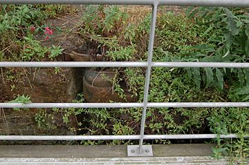
The remains of the Bromley Stop Lock, can be seen amongst the weeds in the bank beyond the 'floating' towpath.
|
|
| Waterway | Limehouse Cut |
|---|---|
| County | Tower Hamlets Greater London |
| Maintained by | N/A |
| Operation | Redundant |
| Fall | Stop lock |
| Distance to Old Ford Lock |
0.25 miles (0.4 km) |
| Distance to Limehouse Basin |
1.75 miles (2.8 km) |
| Coordinates | 51°31′19″N 0°00′35″W / 51.521857°N 0.009832°W |
The Bromley Stop Lock was a special kind of lock on the Limehouse Cut waterway. It was located in the London Borough of Tower Hamlets, close to where the Limehouse Cut meets the River Lee Navigation near Bow Locks.
Contents
What is a Stop Lock?
Why were Stop Locks built?
Stop locks were originally built to control water levels between different parts of a canal system. Imagine two canals owned by different companies. A stop lock would prevent one company from accidentally draining water from the other's canal. This helped keep enough water for boats to travel.
Bromley Stop Lock's Purpose
The Bow Locks, which are nearby, used to be "tidal." This means they would open when the tide was high to let water from the River Thames fill the Limehouse Cut. This helped keep the water level high enough for boats. The Bromley Stop Lock was a backup. If something went wrong with the tidal process, this lock could be closed. This would keep the water in the Limehouse Cut at the right level, matching the water in the Limehouse Basin.
What remains today?
Today, the Bromley Stop Lock is no longer used. It is considered "redundant," meaning it's not needed anymore. Very little of the original structure is left. You can still see one of its gates. It's hidden among weeds behind the modern towpath, which is a path for walking and cycling next to the canal.
How to visit Bromley Stop Lock
Access for walkers and cyclists
You can reach the area of the former lock by walking or cycling along the towpath. This path is part of the longer Lea Valley Walk, a popular route for exploring the area.
Public transport options
If you want to use public transport, the closest train station is Devons Road. This station is part of the Docklands Light Railway (DLR) network.

