Brookville, Ohio facts for kids
Quick facts for kids
Brookville, Ohio
|
|||
|---|---|---|---|

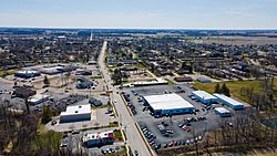
Brookville in 2021
|
|||
|
|||
| Motto(s):
" A Proud And Progressive Community "
|
|||

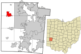
Location in Montgomery County and the state of Ohio.
|
|||
| Country | United States | ||
| State | Ohio | ||
| County | Montgomery | ||
| Area | |||
| • Total | 3.83 sq mi (9.92 km2) | ||
| • Land | 3.83 sq mi (9.92 km2) | ||
| • Water | 0.00 sq mi (0.00 km2) | ||
| Elevation | 1,004 ft (306 m) | ||
| Population
(2020)
|
|||
| • Total | 5,989 | ||
| • Estimate
(2023)
|
5,918 | ||
| • Density | 1,563.71/sq mi (603.74/km2) | ||
| Time zone | UTC-5 (Eastern (EST)) | ||
| • Summer (DST) | UTC-4 (EDT) | ||
| ZIP code |
45309
|
||
| Area code(s) | 937, 326 | ||
| FIPS code | 39-09358 | ||
| GNIS feature ID | 2393433 | ||
| Website | http://www.brookvilleohio.com/ | ||
Brookville is a small city located in the northwestern part of Montgomery County, Ohio, in the United States. It's like a neighbor to the bigger city of Dayton. In 2020, about 5,989 people lived there.
Contents
A Glimpse into Brookville's Past
The first people to settle in the Brookville area arrived around 1814. The town of Brookville was officially planned out in 1850. It got its name from a small brook, or stream, that was located near where the town was built.
Where is Brookville?
Brookville is a city that covers about 3.82 square miles (9.92 square kilometers). All of this area is land, meaning there are no large lakes or rivers within the city limits.
Who Lives in Brookville?
| Historical population | |||
|---|---|---|---|
| Census | Pop. | %± | |
| 1880 | 574 | — | |
| 1890 | 618 | 7.7% | |
| 1900 | 869 | 40.6% | |
| 1910 | 1,187 | 36.6% | |
| 1920 | 1,336 | 12.6% | |
| 1930 | 1,403 | 5.0% | |
| 1940 | 1,653 | 17.8% | |
| 1950 | 1,908 | 15.4% | |
| 1960 | 3,184 | 66.9% | |
| 1970 | 4,403 | 38.3% | |
| 1980 | 4,322 | −1.8% | |
| 1990 | 4,621 | 6.9% | |
| 2000 | 5,289 | 14.5% | |
| 2010 | 5,884 | 11.2% | |
| 2020 | 5,989 | 1.8% | |
| 2023 (est.) | 5,918 | 0.6% | |
| Sources: | |||
In 2010, there were 5,884 people living in Brookville. These people lived in 2,508 homes, and 1,626 of these were families. The city had about 1,540 people per square mile.
Most of the people living in Brookville were White (97.6%). A smaller number were African American (0.4%), Native American (0.1%), or Asian (0.9%). About 0.7% of the population identified as Hispanic or Latino.
About 30.5% of homes had children under 18 living there. Many homes (48%) were married couples. Some homes (12.5%) had a female head of household without a husband. About 31.3% of all homes were single people living alone.
The average age of people in the city was 42.3 years old. About 23.3% of residents were under 18. Also, 22.2% of residents were 65 years old or older.
Schools and Learning
Brookville has its own public school system called Brookville Local Schools. This district includes:
- Brookville Elementary School
- Brookville Intermediate School
- Brookville High School
The city also has a public library. It is a part of the Dayton Metro Library system, where you can borrow books and learn new things.
See also
 In Spanish: Brookville (Ohio) para niños
 | Aaron Henry |
 | T. R. M. Howard |
 | Jesse Jackson |


