Browning Pass / Nōti Raureka facts for kids
Quick facts for kids Browning Pass / Nōti Raureka |
|
|---|---|
| Māori: Nōti Raureka | |

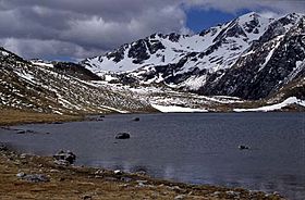
Lake Browning / Whakarewa with Browning Pass / Nōti Raureka in the background
|
|
| Elevation | 1,411 m (4,629 ft) |
| Traversed by | Foot track (Three Passes route) |
| Location | Canterbury |
| Range | Southern Alps / Ka Tiritiri o te Moana |
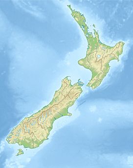
| Coordinates | 42°57′00″S 171°20′40″E / 42.9501°S 171.3444°E |
Browning Pass / Nōti Raureka is a special mountain pass located in the Southern Alps / Kā Tiritiri o te Moana of New Zealand's South Island. It reaches a height of 1411 meters (about 4,629 feet) above sea level. This pass connects the upper part of the Wilberforce River with the West Coast of New Zealand. It has been an important route for centuries, especially for the Māori people.
Contents
History and Name of the Pass
The Story of Raureka
According to Māori traditions, the pass called Nōti Raureka was first found by a woman named Raureka. She belonged to the Kāti Wairaki tribe, who lived on the West Coast. Raureka traveled through the pass and arrived in what is now South Canterbury. There, she met a group from the Ngāi Tahu tribe.
Raureka showed them her special greenstone (pounamu) tool. It was much stronger than the tools the local Māori used. She also described the path she took to get to the eastern side of the island. This amazing story made the Ngāi Tahu people want to explore the area near the Rakaia River and the route Raureka described. The Māori name for the pass, Nōti Raureka, was given in her honor.
Early Conflicts and Trade
At that time, there were some disagreements between the Ngāi Tahu and Kāti Wairaki tribes. They had tried to talk before, but it didn't go well. When Ngāi Tahu discovered Nōti Raureka, a group led by Te Rakitāmau crossed into the West Coast. This led to more tension between the two tribes.
Eventually, Ngāi Tahu gained control of the West Coast. This also gave them control over the valuable pounamu trade. Pounamu was very important for tools and jewelry.
European Exploration and Naming
By the time Europeans arrived in New Zealand, the route over Nōti Raureka was not used as much. Other, safer paths were preferred. In the 1860s, a man named Reverend Canon James West Stack tried to find out about old Māori routes. He found only one elderly man who had actually traveled this pass. All other information came from stories passed down through generations.
The elderly man helped sketch important places along the route. These included Lake Browning / Whakarewa on the western side and a cave near the pass. Soon after, a track was made over the pass for driving farm animals. This helped supply fresh meat to the goldfields on the West Coast. People hoped to build a road over the pass, but other routes like Arthur's Pass were developed instead. So, the Browning Pass track remained a path for pack animals.
The pass was first named Browning Pass by Europeans. It was named after Robert Browning, a surveyor who was part of the first European group to cross it. In 1998, the name was officially changed to Browning Pass / Nōti Raureka. This was part of a Treaty of Waitangi settlement with the Ngāi Tahu tribe. It recognized the importance of the Māori name and history.
Geography of Browning Pass
Browning Pass / Nōti Raureka is located right on the main mountain range of the Southern Alps. It is about 18 kilometers (11 miles) west of the town of Arthur's Pass.
On the Canterbury side, to the south, the route follows the Wilberforce River valley towards Lake Coleridge. From the valley floor, the path climbs about 300 meters (984 feet) to reach the pass itself.
Just north of the pass is Lake Browning / Whakarewa. This lake sits at an altitude of 1360 meters (4,462 feet). From there, the route continues northwest. It follows the start of the Arahura River towards the West Coast. There is also another path that crosses Styx Saddle and goes west along the Styx River.
 | Claudette Colvin |
 | Myrlie Evers-Williams |
 | Alberta Odell Jones |


