Browns Island (California) facts for kids

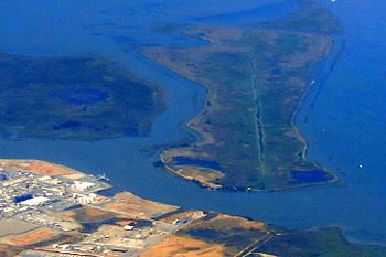
An aerial photo of Browns Island (on the left). Winter Island is on the right of the image, and Antioch is on the bottom.
|
|
| Geography | |
|---|---|
| Location | Suisun Bay |
| Coordinates | 38°02′20″N 121°51′53″W / 38.03881°N 121.86468°W |
| Area | 595 acres (241 ha) |
| Highest elevation | 0 m (0 ft) |
| Administration | |
|
United States
|
|
| U.S. state | California |
| County | Contra Costa County |
| City | Pittsburg |
| Demographics | |
| Population | 0 |
Browns Island is a special natural area in Pittsburg, California. It's also sometimes called Gwin Island or Brown Island. This island is looked after by the East Bay Regional Park District (EBRPD), which means it's a protected place for nature.
Browns Island is located in Suisun Bay, which is part of the larger Sacramento-San Joaquin River Delta. A narrow water channel called New York Slough separates it from the city of Pittsburg. To the east, another channel called Middle Slough separates it from Winter Island. The island covers about 595-acre (241 ha) of land.
What Makes Browns Island Special?
Browns Island is a very important place for nature. It is home to several types of plants that are rare or in danger of disappearing. Many different kinds of water birds also live there. The East Bay Regional Park District has even created a guide to help people learn about the amazing wild plants found on the island.
 | Leon Lynch |
 | Milton P. Webster |
 | Ferdinand Smith |


