Brownsmead, Oregon facts for kids
Quick facts for kids
Brownsmead, Oregon
|
|
|---|---|

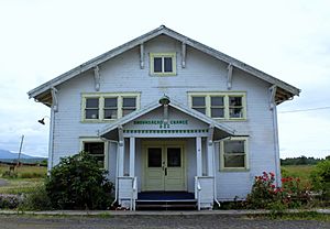
Grange hall
|
|
| Country | United States |
| State | Oregon |
| County | Clatsop |
| Elevation | 10 ft (3 m) |
| Time zone | UTC-8 (Pacific (PST)) |
| • Summer (DST) | UTC-7 (PDT) |
| ZIP code |
97103
|
| Area code(s) | 503 and 971 |
| GNIS feature ID | 1637833 |
Brownsmead is a small place in Clatsop County, Oregon, United States. It's known as an unincorporated community. This means it doesn't have its own local government like a city or town. Instead, it's managed by the county.
Brownsmead is located on a branch of the Columbia River called Saspal Slough. It was once known as Brody. The community got its current name from W.G. Brown. He was an engineer from Portland who helped create new land in the area. This process is called land reclamation.
Discover Brownsmead
Brownsmead is a quiet community with an interesting past. It sits right on the water, near where the Columbia River meets the Pacific Ocean. This location has shaped its history and how people lived there.
Where is Brownsmead?
Brownsmead is in the state of Oregon, in the Clatsop County. It's special because it's the northernmost settlement in Oregon. This means it's the community closest to the state's northern border.
A Bit of History
Brownsmead has been around for a while. It was officially established in 1919. For many years, it had its own post office. This post office was inside the Brownsmead General Store. It served the community from 1919 until 1975.
The area was also important for fishing. Historic photos show a fish station in Brownsmead. This station was located where Davis Creek flows into Blind Slough. These pictures show boats used for gillnetting. Gillnetting is a type of fishing where nets are used to catch fish.
 | Lonnie Johnson |
 | Granville Woods |
 | Lewis Howard Latimer |
 | James West |


