Brownsville, South Carolina facts for kids
Quick facts for kids
Brownsville, South Carolina
|
|
|---|---|

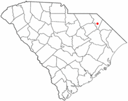
Location of Brownsville, South Carolina
|
|
| Country | United States |
| State | South Carolina |
| County | Marlboro |
| Elevation | 135 ft (41 m) |
| Time zone | UTC-5 (Eastern (EST)) |
| • Summer (DST) | UTC-4 (EDT) |
| ZIP code |
29516
|
| Area code(s) | 843, 854 |
| GNIS feature ID | 1221028 |
Brownsville is a populated place found in Marlboro County, South Carolina, United States. It is a small community where people live.
Exploring Brownsville's Location
This section helps us understand where Brownsville is on a map.
Where is Brownsville Located?
Brownsville is located in the state of South Carolina. You can find it by looking at its exact coordinates. These are like an address for a spot on Earth. Brownsville is at 34.392 degrees North latitude and -79.592 degrees West longitude.
How High is Brownsville?
The elevation of a place tells us how high it is above sea level. Brownsville is 135 feet (about 41 meters) above sea level. This means it's not very high up, like a mountain town, but also not right at the coast.

All content from Kiddle encyclopedia articles (including the article images and facts) can be freely used under Attribution-ShareAlike license, unless stated otherwise. Cite this article:
Brownsville, South Carolina Facts for Kids. Kiddle Encyclopedia.
