
Brownsville, Vermont facts for kids
Quick facts for kids
Brownsville, Vermont
|
|
|---|---|

Brownsville, VT looking west along Route 44
|
|

Location in Windsor County and the state of Vermont.
|
|

Brownsville, Vermont
Location in the United States
|
|
| Country | United States |
| State | Vermont |
| County | Windsor |
| Elevation | 682 ft (208 m) |
| Time zone | UTC-5 (Eastern (EST)) |
| • Summer (DST) | UTC-4 (EDT) |
| ZIP code |
05037
|
| Area code(s) | 802 |
| GNIS feature ID | 1456613 |
Brownsville is a small community in Vermont, United States. It's not a separate town but part of West Windsor. You can find Brownsville along Vermont Route 44. This village is where many of West Windsor's local offices are located.
History of Brownsville
Brownsville got its name from two early settlers, John and Briant Brown. If you want to learn more about the past, the West Windsor Historical Society is right here. They have lots of cool facts about the sheep farms and businesses that helped people live here long ago.
Just east of Brownsville, you'll find the entrance to Ascutney Mountain Resort. This used to be a very popular place for skiing in Vermont. Sadly, it closed in 2010, and its ski lifts were sold in 2014. But in 2015, Brownsville bought the old ski area. They worked with the state of Vermont and a group called the Trust for Public Land to make this happen.
Exploring Brownsville's Nature
Slightly south and west of Brownsville is the Little Ascutney Wildlife Management Area. This is a large area, about 656 acres, that the state owns. It's a special place for nature and animals. You might spot white-tailed deer, bobcats, beavers, and otters living there.
-
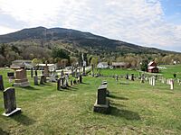
View of town and Mt. Ascutney from the cemetery

Covered Bridges Nearby
Three of Vermont's famous covered bridges are close to Brownsville. These are special bridges with roofs and sides, like a tunnel.
- Best's Bridge is near Churchill Road.
- Bowers Bridge is also nearby.
Both Best's Bridge and Bowers Bridge are listed in the National Register of Historic Places. This means they are important historical sites.
There's also the Twigg Bridge on Yale Road. This bridge was moved to its current spot by a developer. In 2002, strong winds damaged it. Later, in 2011, a big storm called Tropical Storm Irene caused flooding that damaged several bridges, including Bowers Bridge.
-
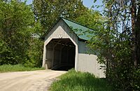
Best's Covered Bridge
-
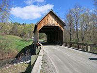
Bowers Covered Bridge
-
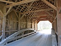
Construction detail of Bowers Bridge


