
Bruce, Alberta facts for kids
Quick facts for kids
Bruce
|
|
|---|---|

Bruce Hotel and Restaurant
|
|

Bruce
Location in Alberta
|
|
| Country | Canada |
| Province | Alberta |
| Census division | No. 10 |
| Municipal district | Beaver County |
| Government | |
| • Type | Unincorporated |
| Area
(2021)
|
|
| • Land | 0.86 km2 (0.33 sq mi) |
| Elevation | 680 m (2,230 ft) |
| Population
(2021)
|
|
| • Total | 65 |
| • Density | 75.7/km2 (196/sq mi) |
| Time zone | UTC-7 (MST) |
| • Summer (DST) | UTC-6 (MDT) |
| Postal Code |
T0B 0R0
|
Bruce is a small community known as a hamlet in Alberta, Canada. It is located within Beaver County. Bruce can be found along Highway 14, between the towns of Viking and Ryley. It is about 115 kilometers (71 miles) east of Edmonton. The land in Bruce is about 680 meters (2,231 feet) above sea level.
The community of Bruce was named after A. Bruce Smith. He was a telephone executive. This hamlet is part of Census Division No. 10. It is also in the federal voting area called Vegreville-Wainwright.
Bruce's Population
The number of people living in Bruce changes over time. This information is collected by Statistics Canada during a census.
How Many People Live Here?
In the year 2021, the census showed that 65 people lived in Bruce. These people lived in 40 homes out of 53 total homes in the hamlet. This was a small increase from 60 people in 2016.
Bruce covers a land area of 0.86 square kilometers (0.33 square miles). This means that in 2021, there were about 75.7 people living in each square kilometer.
Population in Past Years
In the 2016 Census, Bruce had a population of 50 people. They lived in 31 homes out of 51 total homes. This was a decrease from 60 people in 2011. The population density in 2016 was about 58.1 people per square kilometer.
Images for kids
-
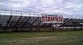
A view of the Bruce Stampede.
-
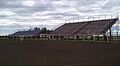
The arena at the Bruce Stampede.


