Brush Creek (Bryant Creek tributary) facts for kids
Quick facts for kids Brush Creek |
|
|---|---|

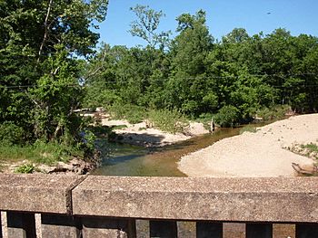
Brush Creek looking north from Missouri route 14 bridge. Confluence of Little Brush Creek (right) and Brush Creek (left)
|
|
| Country | United States |
| State | Missouri |
| Region | Douglas County and Ozark County |
| Physical characteristics | |
| Main source | 36°55′09″N 92°15′31″W / 36.91917°N 92.25861°W |
| River mouth | 692 ft (211 m) 36°46′49″N 92°20′56″W / 36.78028°N 92.34889°W |
Brush Creek is a small stream located in the southern part of Missouri, in the United States. It flows through two counties: Douglas and Ozark. These areas are part of the beautiful, hilly region known as the Ozarks. Brush Creek is a "tributary," which means it is a smaller stream that flows into a larger one. This creek eventually joins Bryant Creek.
Brush Creek's Journey
Brush Creek begins its journey on the side of a hill called Twin Knobs Peak. This peak is about 1,404 feet high. At first, the stream is "intermittent," meaning it doesn't always flow with water. It might dry up during certain times of the year.
Starting Point
The very beginning of Brush Creek is on the southwest side of Twin Knobs Peak. From there, it flows towards the southwest. Soon after it starts, the stream crosses under a road called Missouri Route W. This happens just southwest of its source.
Along the Way
As Brush Creek continues its path, it flows past a small community named Buckhart. The stream keeps moving southwest, eventually passing under another road, Missouri Route 14. This crossing is about 1.5 miles east of a place called Gentryville.
The creek then flows alongside Missouri Route 95. It keeps heading southwest, eventually entering Ozark County.
Where It Ends
About one mile after entering Ozark County, Brush Creek reaches its end. It flows into Bryant Creek. The spot where these two creeks meet is about 692 feet above sea level. This is where Brush Creek's journey finishes, as its waters become part of Bryant Creek.
 | Janet Taylor Pickett |
 | Synthia Saint James |
 | Howardena Pindell |
 | Faith Ringgold |

