Brushy Mountain (conservation area) facts for kids
Quick facts for kids Brushy Mountain |
|
|---|---|
| Location | Bland County Virginia, United States |
| Nearest town | Bland, Virginia |
| Area | 4,183 acres (16.93 km2) |
| Administrator | U.S. Forest Service |
Brushy Mountain is a special natural area located in the George Washington and Jefferson National Forests in western Virginia. It's a wild place that the Wilderness Society believes should be protected. They call it a "Mountain Treasure" because it's so important to keep it safe from things like logging and building new roads.
This area is very popular with people who love to hike and hunt. It has about seven miles of the famous Appalachian Trail! The U.S. Forest Service also thinks it's a beautiful place, saying that almost all of it (about 98%) looks really natural and untouched. Brushy Mountain is part of a larger group of wildlands called the Kimberling Creek Cluster.
Contents
Exploring Brushy Mountain: Location and Trails
Brushy Mountain is found in the Appalachian Mountains of Southwestern Virginia. It's just east of Interstate 77 and about 3 miles northeast of Bland, Virginia. Roads like VA 42 and VA 612 help mark its edges.
Hiking the Appalachian Trail
The famous Appalachian Trail goes right through Brushy Mountain. It mostly follows the top of Brushy Mountain from east to west. This trail is a great way to explore the area.
Here are some points along the trail if you're hiking south:
- 0.0 mile: Start at the trailhead on VA 611.
- 2.2 miles: Turn left to follow an old road.
- 4.5 miles: Turn right onto a path.
- 5.7 miles: Go up a road.
- 6.6 miles: You'll see a short trail (0.3 miles) on your left leading to Helveys Mill Shelter.
- 6.8 miles: Bear right to go down a woods road.
- 7.7 miles: Follow an old railroad path.
- 7.9 miles: Cross Kimberling Creek (the water here is not safe to drink).
- 8.0 miles: You've reached the trailhead on VA 612.
Old Roads and Maps
There are no paved roads inside Brushy Mountain. But you might find about 2.6 miles of old logging roads. These are usually overgrown and can only be walked on. You can find these old paths by looking at historical maps from the United States Geological Survey (USGS). The maps that cover Brushy Mountain are called Bland and Rocky Gap.
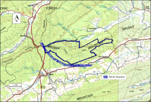
The map next to this text shows the boundary of the wildland, as identified by the Wilderness Society. You can find more trails and roads on National Geographic Maps 787 (Blacksburg, New River Valley). For even more details, like satellite views and weather, you can click the coordinates link at the top right of this page.
The Kimberling Creek Wilderness area is located just north of Brushy Mountain.
Nature's Beauty: Trees and Forests
Brushy Mountain is part of a large natural area called the Central Appalachian Broadleaf Coniferous Forest-Meadow Province. This means you'll find many different kinds of trees here!
Types of Trees You Might See
In the valleys and along small streams, you can spot trees like yellow poplar, northern red oak, white oak, and eastern hemlock. On the tops of ridges, you'll mostly see white oak, northern red oak, and hickory. In drier, more open spots, there are chestnut oak, scarlet oak, and yellow pine.
You might even find some rare table mountain pine trees. These trees are special because they need fire to help their seeds grow.
Old Growth Forests
Brushy Mountain has about 430 acres of what's called "potential old growth forest." This means these parts of the forest have very old, large trees and have been mostly untouched by humans for a long time. They are important for wildlife and the environment.
The Lay of the Land: Mountains and Creeks
Brushy Mountain is part of the Ridge-and-Valley Appalachians. This area has long, parallel ridges made of sandstone and shale, with valleys in between made of limestone or shale.
Waterways of Brushy Mountain
Two main creeks, Kimberling Creek to the north and Helveys Mill Creek to the south, get their water from many smaller streams that start in Brushy Mountain. Kimberling Creek doesn't have enough water for sport fishing. Helveys Mill Creek used to power a mill in a town called Point Pleasant. A spring near the Helveys Mill Shelter on the Appalachian Trail is one of the sources for this creek.
The lowest point in Brushy Mountain is 2280 feet along Kimberling Creek. The highest point is 3250 feet, which is on the very top of Brushy Mountain.
How the Forest Service Protects Brushy Mountain
The U.S. Forest Service looks at its lands to decide which areas should be protected as "wilderness." When an area is designated as wilderness, it gets a high level of protection from development.
Protecting Roadless Areas
Areas that might be suitable for wilderness protection are called "inventoried roadless areas." A rule was later made to limit building roads in these places. This rule helps protect the environment by reducing the impact of road construction. Brushy Mountain was included in this review, so it's protected from new roads and timber sales.
Power Lines and Recreation
A large power line was built by American Electric Power along the southwestern edge of Brushy Mountain. Some people are concerned about how this power line might affect the forest and its wildlife.
The Forest Service also describes how visitors can enjoy the forest. Most of Brushy Mountain is called "Remote Backcountry-Non-motorized." This means it's a quiet place where you can't use motorized vehicles. A smaller part is called the "Appalachian Trail Corridor," which is specifically for hikers on the trail.
A Look Back: Cultural History
While Brushy Mountain might have some old historical or prehistoric sites, a survey done in 1998 didn't find any specific ones.


