Buffalo River (Virginia) facts for kids
Quick facts for kids Buffalo River (Virginia) |
|
|---|---|

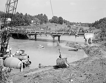
A bridge across the Buffalo River which was washed out by Hurricane Camille in 1969
|
|
| Country | United States |
| Physical characteristics | |
| Main source | Virginia |
The Buffalo River is a river in Virginia, a state in the United States. It flows for about 31.5 miles (50.7 kilometers). This river is a smaller stream, also known as a tributary, that flows into the Tye River. Both the Buffalo River and the Tye River are part of a larger water system called the James River watershed. A watershed is an area of land where all the water drains into a common river, lake, or ocean.
Where Does the Buffalo River Start and End?
The Buffalo River begins at the eastern base of the Blue Ridge Mountains. This area is known as Forks of Buffalo. Here, two smaller streams, the North Fork and the South Fork of the Buffalo River, join together. This starting point is located in Amherst County, near U.S. Route 60.
The River's Journey Through Virginia
From its start, the main part of the Buffalo River flows towards the southeast. It passes just north of the town of Amherst, which is the main town in Amherst County. After that, the river changes direction and turns towards the northeast. It then flows into Nelson County. Finally, the Buffalo River meets the Tye River northeast of a small community called Piedmont.
 | Aurelia Browder |
 | Nannie Helen Burroughs |
 | Michelle Alexander |

