Tye River facts for kids
Quick facts for kids Tye River |
|
|---|---|

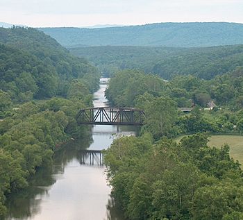
From a bluff in James River State Park, the Tye River is seen looking upstream just west of its confluence with the James River, near Norwood in Nelson County, Virginia
|
|
| Country | United States |
| Physical characteristics | |
| Main source | Virginia 1,270 feet (390 m) |
| River mouth | James River 350 feet (110 m) 37°38′24″N 78°48′25″W / 37.640°N 78.807°W |
| Length | 35.4 miles (57 km) |
The Tye River is a river in central Virginia, United States. It is about 35.4-mile-long (57.0 km). The Tye River is a tributary, which means it flows into a larger river. It joins the James River.
The Tye River starts on the eastern side of the Blue Ridge Mountains. It gets water from other rivers like the Piney River and the Buffalo River. All this water eventually flows into the Chesapeake Bay.
Even though the Tye River is usually a smaller river, it was part of a huge natural disaster in August 1969. A very strong storm called Hurricane Camille caused a lot of rain to fall in Nelson County. This led to terrible floods and mudslides. Many communities were badly damaged, and many people lost their lives. Roads, bridges, and communication lines were broken for days.
Today, the Tye River is a beautiful place for outdoor fun in Virginia. There is even a special memorial in Massies Mill. It honors those who were affected by the 1969 disaster.
Contents
Where the Tye River Flows
The Tye River begins where its two main branches meet. These are called the North Fork and the South Fork. This meeting point is near a village called Nash. It is in northern Nelson County, Virginia, on the eastern side of the Blue Ridge Mountains.
The North Fork starts near the Blue Ridge Parkway. It flows for about 8.7 miles (14.0 km) before joining the South Fork. The South Fork also starts near the Blue Ridge Parkway. It flows for about 7.6 miles (12.2 km) to meet the North Fork at Nash.
From Nash, the Tye River flows mostly southeast through central Nelson County. The Piney River also flows into the Tye River. The Tye River then joins the James River near Norwood. This area is close to James River State Park.
Some towns and communities along the Tye River include Tyro, Massies Mill, Roseland, and Tye River. All these places are in Nelson County.
History of the Tye River Area
A long time ago, a railroad called the Virginia Blue Ridge Railway ran along the upper part of the Tye River. This railroad was built in 1915. It was first used to carry lumber from the many chestnut trees in the area. But in the 1920s, a disease called chestnut blight destroyed most of these trees. Later, the railroad carried small amounts of minerals from nearby mines. This mining stopped by 1970. The train stopped carrying passengers in 1939. The railroad tracks were no longer used after the 1980s.
The Great Flood of 1969
On the night of August 20, 1969, the Tye River area experienced one of Virginia's worst natural disasters. A few days earlier, Hurricane Camille had hit the Gulf Coast as a very powerful storm. It caused a lot of damage and flooding there.
As the storm moved inland, it lost some strength. But when it reached Nelson County in Virginia, it unexpectedly stopped. In just about three hours, a record 27 inches (690 mm) of rain fell. This was an incredible amount of water. People reported that the rain was so heavy, it was hard to breathe outside.
While many people were sleeping, flash floods and mudslides quickly happened. These floods caused many deaths. For example, 22 people died in Massies Mill alone. Across Nelson County, 133 bridges were washed away. Some whole communities were covered in water. The town of Waynesboro had 8 feet (2.4 m) of water in its downtown. Buena Vista had more than 5 feet (1.5 m) of water.
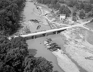
Every bridge over the Tye River was destroyed. This included a major highway bridge and a railroad bridge. The floodwaters from the Tye River then flowed into the James River. This caused huge floods downstream, even reaching Richmond.
In Nelson County, some people's bodies were never found. Others were carried far downstream by the floodwaters. The entire county was cut off. Many roads, almost all bridges, and all phone and electric services were broken. The total damage in Virginia was very high.
Fish and Wildlife in the Tye River
The Tye River is home to many kinds of fish and other water animals. You can find American eels, smallmouth bass, largemouth bass, and native mussels here. In 2007, a dam was removed from the river. This helps fish move more freely up and down the river. It also helps increase the number of fish and makes it easier for people to fish, paddle, and boat.
Fun Activities on the Tye River
The Tye River is a popular spot for fishing and camping. Many people also enjoy whitewater boating, like canoeing and kayaking. The river has rapids that are usually Class I to Class II+. This means they are good for beginners and intermediate paddlers. Sometimes, depending on the water level, some rapids can be Class III, which are a bit more challenging.
Parts of the old Virginia Blue Ridge Railway are now being turned into a walking and biking path. This path is called the Blue Ridge Railway Trail. It will eventually connect the James River to the Blue Ridge Parkway and the famous Appalachian Trail.
 | Ernest Everett Just |
 | Mary Jackson |
 | Emmett Chappelle |
 | Marie Maynard Daly |


