Burke Island facts for kids
 |
|
|
Location in Antarctica
|
|
| Geography | |
|---|---|
| Location | Antarctica |
| Coordinates | 73°7′48″S 105°6′0″W / 73.13000°S 105.10000°W |
| Area | 355 km2 (137 sq mi) |
| Length | 30 km (19 mi) |
| Width | 11 km (6.8 mi) |
| Administration | |
| Administered under the Antarctic Treaty System | |
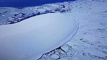
Burke Island is a large island covered in ice. It is about 30 kilometers (16 miles) long and 11 kilometers (6 miles) wide. This icy island is found in the Amundsen Sea. This sea is part of the huge Southern Ocean that surrounds Antarctica. Burke Island lies about 69 kilometers (37 miles) southwest of Cape Waite, which is on the King Peninsula.
Discovering Burke Island
Scientists first mapped Burke Island using pictures taken from the air. These photos were captured by a special U.S. Navy airplane squadron called VX-6. They flew over the area in January 1960. These aerial photos helped experts draw the island's shape and location.
How Burke Island Got Its Name
The United States Advisory Committee on Antarctic Names (US-ACAN) officially named Burke Island. They chose to name it after Admiral Arleigh A. Burke. He was a very important leader in the United States Navy. Admiral Burke served as the Chief of Naval Operations (CNO) during a big operation called Operation Deep Freeze. This operation took place from 1956 to 1961. The CNO is the highest-ranking officer in the U.S. Navy. Operation Deep Freeze was a series of missions by the U.S. military to explore and research Antarctica.


